Posts: 1578 From: BELFAST, UNITED KINGDOM Registered: Feb 2002
posted September 06, 2009 12:22 PM
quote:Originally posted by FFrench: I had a very nice opportunity to talk to Al Bean about the image the day after it was released, as he is here at the museum...
Hmmm, seems like you pointed your camera a bit too close to the sun, there, Francis!
FFrench Member
Posts: 2902 From: San Diego Registered: Feb 2002
posted September 08, 2009 07:01 PM
quote:Originally posted by Blackarrow: Hmmm, seems like you pointed your camera a bit too close to the sun, there, Francis!
That always seems to happen when Al is around, doesn't it?!
Scott Member
Posts: 3248 From: Houston, TX Registered: May 2001
posted September 10, 2009 11:09 AM
From the LRO blog:
A review was held yesterday, September 9th, during which it was verified LRO is ready to proceed to the 50km polar mapping orbit and begin the prime mission. On September 15th LRO will execute the Mission Orbit Insertion (MOI) propulsive maneuver and establish the nominal mission orbit..."
Robert Pearlman Editor
Posts: 21917 From: Houston, TX Registered: Nov 1999
posted September 16, 2009 03:42 AM
From the LRO blog:
LRO Mission Orbit Insertion Completed!
Today [Sept. 15] at 3:32pm ET LRO executed a 3 minute propulsion burn near the periselene of our last commissioning phase orbit. This placed LRO in a 50 km (mean) circular polar orbit about the Moon. With this maneuver LRO has begun its primary 1 year Exploration mission.
Robert Pearlman Editor
Posts: 21917 From: Houston, TX Registered: Nov 1999
posted September 16, 2009 03:43 AM
NASA release
NASA to Release First Results from Lunar Mission Thursday, Sept. 17
NASA will showcase new images from the Lunar Reconnaissance Orbiter's seven instruments and provide updates about the topography of the moon's south pole during a news conference at 1 p.m. EDT Thursday, Sept. 17. NASA also will provide an update about the spacecraft's status and mission plans. The briefing will take place at NASA's Goddard Space Flight Center in Greenbelt, Md., and will be broadcast live on NASA Television and the agency's Web site.
Panelists are:
Craig Tooley, Lunar Reconnaissance Orbiter project manager, Goddard Space Flight Center
Michael Wargo, chief lunar scientist, Exploration Systems Mission Directorate, NASA Headquarters, Washington
Richard Vondrak, Lunar Reconnaissance Orbiter project scientist, Goddard
David Smith, Lunar Orbiter Laser Altimeter principal investigator, Goddard
Robert Pearlman Editor
Posts: 21917 From: Houston, TX Registered: Nov 1999
posted September 17, 2009 12:30 PM
NASA release
NASA Lunar Satellite Begins Detailed Mapping of Moon's South Pole
NASA reported Thursday that its Lunar Reconnaissance Orbiter, or LRO, has successfully completed its testing and calibration phase and entered its mapping orbit of the moon. The spacecraft already has made significant progress toward creating the most detailed atlas of the moon's south pole to date. Scientists released preliminary images and data from LRO's seven instruments.
"The LRO mission already has begun to give us new data that will lead to a vastly improved atlas of the lunar south pole and advance our capability for human exploration and scientific benefit," said Richard Vondrak, LRO project scientist at NASA's Goddard Space Flight Center in Greenbelt, Md.
LRO is scheduled for a one-year exploration mission in a polar orbit of about 31 miles above the lunar surface, the closest any spacecraft has orbited the moon. During the next year, LRO will produce a complete map of the lunar surface in unprecedented detail, search for resources and safe landing sites for human explorers, and measure lunar temperatures and radiation levels.
"The LRO instruments, spacecraft, and ground systems continue to operate essentially flawlessly," said Craig Tooley, LRO project manager at Goddard "The team completed the planned commissioning and calibration activities on time and also got a significant head start collecting data even before we moved to the mission's mapping orbit."
The south pole of the moon is of great interest to explorers because potential resources such as water ice or hydrogen may exist there. Permanently shadowed polar craters that are bitterly cold at their bottoms may hold deposits of water ice or hydrogen from comet impacts or the solar wind. The deposits may have accumulated in these "cold-trap" regions over billions of years. If enough of these resources exist to make mining practical, future long-term human missions to the moon potentially could save the considerable expense of hauling water from Earth.
First results from LRO's Lunar Exploration Neutron Detector, or LEND, indicate that permanently shadowed and nearby regions may harbor water and hydrogen. Additional observations will be needed to confirm this. LEND relies on a decrease in neutron radiation from the lunar surface to indicate the presence of water or hydrogen.
"If these deposits are present, an analysis of them will help us understand the interaction of the moon with the rest of the solar system," Vondrak said.
Data from LRO's Lunar Orbiter Laser Altimeter, or LOLA, however, indicates that exploring these areas will be challenging because the terrain is very rough. The roughness is probably a result of the lack of atmosphere and absence of erosion from wind or water, according to David Smith, LOLA principal investigator at Goddard.
LRO's other instruments also are providing data to help map the moon's terrain and resources. According to the first measurements from the Diviner instrument, large areas in the permanently shadowed craters are about minus 400 degrees Fahrenheit (33 Kelvin), more than cold enough to store water ice or hydrogen for billions of years.
The Lunar Reconnaissance Orbiter Camera is providing high-resolution images of permanently shadowed regions while lighting conditions change as the moon's south pole enters lunar summer.
LRO's Lyman Alpha Mapping Project, or LAMP, also is preparing to search for surface ice and frost in the polar regions. The instrument provides images of permanently shadowed regions illuminated only by starlight and the glow of interplanetary hydrogen emission. LAMP has provided information to confirm the instrument is working well on both the lunar night and day sides.
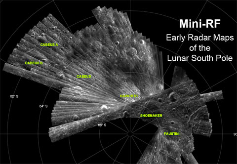
The Mini RF Technology Demonstration on LRO has confirmed communications capability and produced detailed radar images of potential targets for LRO's companion mission, the Lunar Crater Observation and Sensing Satellite, which will impact the moon's south pole on Oct. 9.
Meanwhile, LRO's Cosmic Ray Telescope for the Effects of Radiation instrument is exploring the lunar radiation environment and its potential effects on humans during record high, "worst-case" cosmic ray intensities accompanying the extreme solar minimum conditions of this solar cycle.
Goddard built and manages LRO, a NASA mission with international participation from the Institute for Space Research in Moscow. Russia provides the neutron detector aboard the spacecraft.
Credit: NASA/APL/LPI
DChudwin Member
Posts: 686 From: Lincolnshire IL USA Registered: Aug 2000
posted September 19, 2009 08:26 AM
According to the first measurements from the Diviner instrument, large areas in the permanently shadowed craters are about minus 400 degrees Fahrenheit (33 Kelvin), more than cold enough to store water ice or hydrogen for billions of years.
This is amazing! What is in those craters is a "time capsule" of the development of the Moon. I knew it is cold in permanently shadowed areas, but I did not realize as low as 33 K.
Philip Member
Posts: 4360 From: Brussels, BELGIUM Registered: Jan 2001
posted September 20, 2009 06:54 AM
It would be interesting to see the resting places of unmanned Moon explorers of the 1960s on LRO images, such as Surveyor V.
Robert Pearlman Editor
Posts: 21917 From: Houston, TX Registered: Nov 1999
posted September 29, 2009 04:10 PM
LROC News System
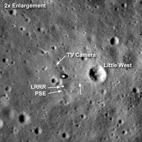
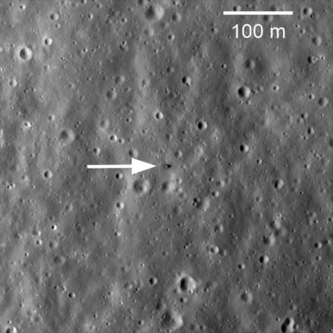
Apollo 11: Second look
A month after LROC's first image of the Apollo 11 landing site was acquired, LRO passed over again providing LROC a new view of the historic site. This time the Sun was 28 degrees higher in the sky, making for smaller shadows and bringing out subtle brightness differences on the surface. The look and feel of the site has changed dramatically.
The astronaut path to the TV camera is visible, and you may even be able to see the camera stand (arrow). You can identify two parts of the Early Apollo Science Experiments Package (EASEP) - the Lunar Ranging Retro Reflector (LRRR) and the Passive Seismic Experiment (PSE). Neil Armstrong's tracks to Little West crater (33 m diameter) are also discernable (unlabeled arrow). His quick jaunt provided scientists with their first view into a lunar crater.
Explore the full resolution LROC NAC image and find the landing site on your own.
Credit: NASA/GSFC/Arizona State University
Scott Member
Posts: 3248 From: Houston, TX Registered: May 2001
posted September 30, 2009 04:37 PM
LROC News System
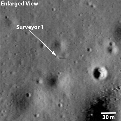
Surveyor 1: America's first soft lunar landing
Surveyor 1 was the first in a series of seven US missions to the Moon that preceded Apollo; five of the seven missions were successful. Surveyor 1 was launched on May 30, 1966 and landed on June 2, 1966. The mission's objectives were to soft land on the Moon and to collect information on the lunar regolith. This first Surveyor spacecraft carried only a television camera system (later missions carried additional instruments). The spacecraft landed on a relatively smooth mare surface in Oceanus Procellarum (the Ocean of Storms). The Surveyor 1 landing site is also one of the areas identified by Project Constellation as a high-priority target for future human lunar exploration.
The scene shows the spacecraft (annotated with an arrow) just south of a subdued 40 m diameter crater and about 110 m northwest of a 190 m diameter crater lined with boulders. The landing site is in the northeast corner of the Flamsteed Ring, a 100 km diameter impact crater almost completely buried by mare lavas such that all that remains exposed is the upper part of the original crater rim.
Surveyor 1 collected over 11,000 images, most during the first lunar day between landing and July 7, 1966. The spacecraft continued to operate until January 7, 1967. The Surveyor images demonstrated that the lunar surface was strong enough to support a landed vehicle or a human. The detailed images also indicated that the surface was composed of a granular material interpreted to be produced by the impact of various size meteors over billions of years.
Explore the full-resolution NAC image of the Surveyor 1 site.
posted October 08, 2009 12:58 PM
Has there been any thought in using the LRO to try and find and photograph the impact sites of the Lunar Module ascent stages or SIVB’s? It might be interesting to investigate.
tegwilym Member
Posts: 2186 From: Renton, WA USA Registered: Jan 2000
posted October 08, 2009 08:24 PM
Apollo 14 S-IVB was just found today.
Credit: NASA/Goddard Space Flight Center/Arizona State University
The crater in the center of this image was formed by Apollo 14's Saturn IVB booster. The booster was intentionally impacted into the lunar surface on Feb. 4, 1971. The impact caused a minor "moonquake" that scientists used to learn about the moon's interior structure. Seismometers placed on the surface by Apollo astronauts returned data on the tremor.
Scott Member
Posts: 3248 From: Houston, TX Registered: May 2001
posted October 29, 2009 08:01 AM
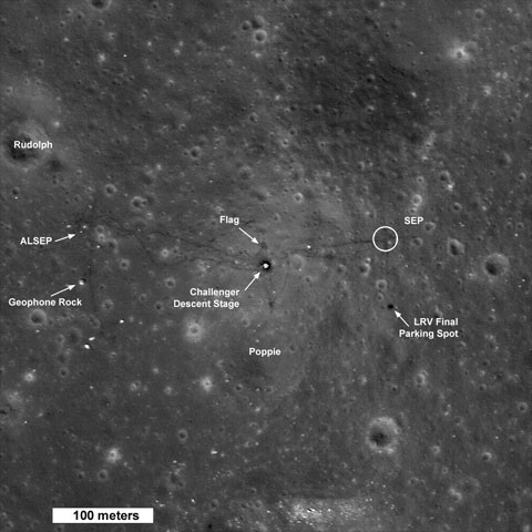
The Apollo 17 landing site has been re-imaged from the new 50 km mapping orbit, with more detail visible now.
Exploring the Apollo 17 Site
LRO maneuvered into its 50-km mapping orbit on September 15. The next pass over the Apollo 17 landing site resulted in images with more than two times better resolution than previously acquired.
At the time of this recent overflight the Sun was high in the sky (28° incidence angle) helping to bring out subtle differences in surface brightness.
The descent stage of the lunar module Challenger is now clearly visible, at 50-cm per pixel (angular resolution) the descent stage deck is eight pixels across (four meters), and the legs are also now distinguishable. The descent stage served as the launch pad for the ascent stage as it blasted off for a rendezvous with the command module America on 14 December 1972.
Tracks are clearly visible and can be followed to the east, where astronauts Jack Schmitt and Gene Cernan set up the Surface
Electrical Properties (SEP) experiment. Cernan drove the Lunar Roving Vehicle (LRV) in an intersecting north-south and east-west course to mark positions for laying out the SEP thirty-five meter antennas (circle labeled "SEP" marks the area of the SEP transmitter). The dark area just below the SEP experiment is where the astronauts left the rover, in a prime spot for monitoring the liftoff...
Credit: NASA/GSFC/Arizona State University
FFrench Member
Posts: 2902 From: San Diego Registered: Feb 2002
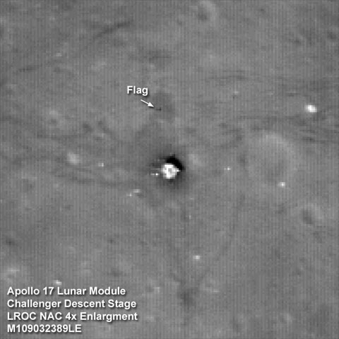
posted November 02, 2009 11:14 PM
Can we tell from the shadow in this low-pixel (at high zoom) image whether the flag has survived at all, or whether (as many predicted) the fabric has disintegrated, leaving only the vertical and horizontal pole assembly?
Robert Pearlman Editor
Posts: 21917 From: Houston, TX Registered: Nov 1999
posted November 04, 2009 04:07 PM
NASA release
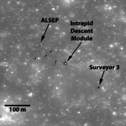
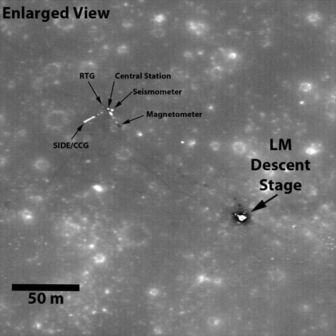
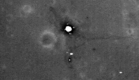
Apollo 12 Landing Site
The LROC team released their first view of the Apollo 12 landing site earlier this year. Even though that image was collected from the higher LRO commissioning phase orbit, details of the landing site could be discerned, including the trails followed by Astronauts Charles Conrad and Alan Bean, the descent module of the Lunar Module (LM) Intrepid, and the Surveyor 3 robotic lander.
From the lower mapping orbit (50 km) even more details of the landing site are revealed. With the Sun very high in the sky (incidence angle 4°), shadows are minimized and you mostly see variations in albedo (or surface brightness). On the Moon, albedo variations are generally due to either composition (mare vs highlands) or maturity (since fresh, impact-excavated lunar materials tend to have higher albedo, but gradually darken after prolonged exposure to the space environment). Since we're viewing a mare surface far away from highland materials in this image, the albedo variations that you can see are dominantly due to maturity effects. However it is clear from all the LROC landing site images that astronaut activity lowers the albedo, areas of heaviest activity have the lowest albedo, especially around the LM. This effect is most likely due to compaction of a very loose surface powder by simply walking around. The more walking in a given area, the more compaction that takes place, and thus the lower the albedo.
Credit: NASA/GSFC/Arizona State University
Jeff Member
Posts: 159 From: Fayetteville, NC, USA Registered: May 2009
posted November 07, 2009 06:33 AM
Just curious…After I enlarged the image I noticed 2 dark spots or shadows to the front right (direction of flight)of the descent stage. That’s to say, Quad 4 between the +Z and +Y footpads...a little way out from the LM. Could these shadows possible be the S-Band antenna…that was eventually blown over during the crews “hot fire” of the RCS prior to ascent, and the flag? Does anyone else see that, or am I just imagining it?
mmmoo Member
Posts: 377 From: London, England Registered: May 2001
posted November 07, 2009 06:48 AM
On this Apollo 12 panorama you can see two dark depressions in the surface, could that be the two dark spots?
Posts: 159 From: Fayetteville, NC, USA Registered: May 2009
posted November 07, 2009 07:22 AM
That's a good point, but I'm not really convinced, only because the new image was taken with the sun very high over head, which has a tendency to wash out any surface shadows made from depressions. Case in point, when I look at the first image that is labeled and shows Surveyor 3, the "Belly of the Snowman" is not visible to me... and that's a pretty large depression. That's why I think it's something that is standing "above" the surface, not depressed in it, and the two shadows are in the "historically correct" location of the S-Band and Flag.
Jeff Member
Posts: 159 From: Fayetteville, NC, USA Registered: May 2009
posted November 07, 2009 08:09 AM
quote:Originally posted by FFrench: Can we tell from the shadow in this low-pixel (at high zoom) image whether the flag has survived at all, or whether (as many predicted) the fabric has disintegrated, leaving only the vertical and horizontal pole assembly?
That's partly what I'm asking in relation to the Apollo 12 image. As you stated, it's been predicted that the flags that we left would have long ago turned black and disintegrated. But, if that's the case why would there be a shadow that stands out so prominently on the Apollo 17 image? The flag pole was what... 3 or 4 centimeters in diameter? I find it hard to believe that the pole with yardarm alone would cast such a visible shadow.
Rick Boos Member
Posts: 771 From: Celina,Ohio U.S.A. Registered: Feb 2000
posted November 07, 2009 11:59 AM
Jeff, good point! I was thinking the same thing!
Robert Pearlman Editor
Posts: 21917 From: Houston, TX Registered: Nov 1999
posted November 09, 2009 04:04 PM
NASA release
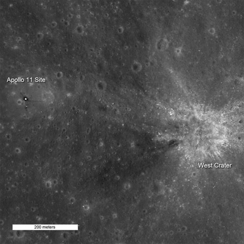
LRO Gets Additional View of Apollo 11 Landing Site
"Houston, Tranquility Base here. The Eagle has landed."
With those eight words, astronaut Neil Armstrong let the world know that Apollo 11 had landed safely on the moon, beginning humankind's first exploration of another world. The landing certainly kept the mission operations crew in suspense as Armstrong maneuvered around the bouldery ejecta on the northeast flank of West Crater, finally settling down almost a kilometer to the west with only tens of seconds of fuel remaining.
The Lunar Reconnaissance Orbiter Camera team earlier released two pictures of the Apollo 11 landing site, each taken under different lighting conditions and at lower resolution than this image. This is LROC's first picture of Apollo 11 after LRO dropped into its 50 km mapping orbit. At this altitude, very small details of Tranquility Base can be discerned. The footpads of the LM are clearly discernible. Components of the Early Apollo Science Experiments Package (EASEP) are easily seen, as well. Boulders from West Crater lying on the surface to the east stand out, and the many small craters that cover the moon are visible to the southeast.
Credit: NASA/GSFC/Arizona State University
As the Apollo 11 Lunar Module (LM) neared the surface, Neil Armstrong could see the designated landing area would have been in a rocky area near West Crater. He had to change the flight plan and fly the LM westward to find a safe landing spot. This image is 742 meters wide (about 0.46 miles). North is towards the top of the image.
Credit: NASA/GSFC/Arizona State University
Enlargement of area surrounding Apollo 11 landing site.
Robert Pearlman Editor
Posts: 21917 From: Houston, TX Registered: Nov 1999
posted March 15, 2010 09:32 PM
NASA release
New Lunar Images and Data Available to the Public
The public can follow along with NASA on its journey of lunar discovery. On March 15, the publicly accessible Planetary Data System will release data sets from the seven instruments on board NASA’s Lunar Reconnaissance Orbiter.
“The Planetary Data System is a NASA funded program to archive data from past and present planetary missions as well as astronomical observations and laboratory data,” said Dr. John Keller, LRO Deputy Project Scientist from NASA Goddard Space Flight Center in Greenbelt, Md. “The purpose of the Planetary Data System is to make available to the public the fruits of NASA funded research and to allow advanced research on solar system science.”
Each of the seven instruments is unique and will provide data in different formats to the Planetary Data System. Much of the data will be in a relatively low level form, not highly processed, which allows researchers to maximize flexibility in working with the data. The instrument teams will also provide higher level data products in the form of maps and calibrated images for the general public. Many of the images can be accessed using a computer with an internet browser.
Prior to the formal release of LRO data, the Lunar Reconnaissance Orbiter Camera team released several hundred images from the pair of Narrow Angle Cameras on-board the spacecraft. These images were released to give researchers a head start on using the data before the tidal wave of data was unleashed.
“We're able to take advantage of the close proximity of the Moon, compared to other objects in the solar system, to transmit data from LRO back to Earth at a very high rate,” said Keller. “The first data release is 55 terabytes. The one year exploration mission will deliver 130 terabytes of data, enabling a more detailed study our nearest celestial neighbor. We expect LRO to provide more data than all of the previous planetary missions combined.”
LRO was mandated to release data to the Planetary Data System beginning six months after initial operation. Some of the higher level data products require the full year of measurements and won't be released until after the end of the exploration mission. LRO will move into its science phase in September, when the program management responsibility moves from the Exploration Systems to the Science Mission Directorate at NASA Headquarters.
LRO is scheduled for a one year exploration mission in a polar orbit about 31 miles above the lunar surface. During this time, LRO will produce a comprehensive map of the lunar surface in unprecedented detail, search for resources and potential safe landing sites for a potential future return to the moon and measure lunar temperatures and radiation levels.
Robert Pearlman Editor
Posts: 21917 From: Houston, TX Registered: Nov 1999
posted March 15, 2010 09:46 PM
Lunar Reconnaissance Orbiter has imaged the Soviet Union's Luna 20 and 24:
Credit: NASA/GSFC/Arizona State University
On February 21, 1972, Luna 20 soft landed in the rugged highlands between Mare Fecunditatis and Mare Crisium. The next day a sample return capsule blasted off carrying 55 grams of lunar soil. The Luna 20 descent stage still sits silently on the Moon, clearly visible in LROC NAC image M119482862RE.
Credit: NASA/GSFC/Arizona State University
Luna 20 descent stage, note the shadow of the sampling arm.
Credit: NASA/GSFC/Arizona State University
Luna 24 sitting on the edge of a 60 meter diameter crater, NAC image M119449091RE.
Robert Pearlman Editor
Posts: 21917 From: Houston, TX Registered: Nov 1999
posted March 23, 2010 01:23 PM
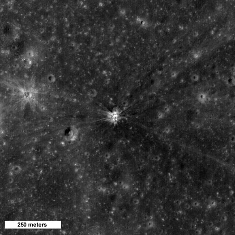
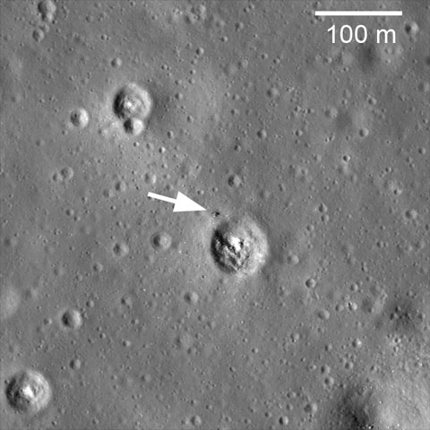
Lunar Reconnaissance Orbiter has imaged the impact site of Apollo 13's S-IVB:
Credit: NASA/GSFC/Arizona State University
Bang! On April 14th 1970, the Apollo 13 Saturn IVB upper stage impacted the Moon North of Mare Cognitum, at -2.55° latitude, -27.88° East longitude. The impact crater, which is roughly 30 meters in diameter, is clearly visible in LROC NAC image M109420042LE.
Rocket impacts recorded by the Apollo seismic network
In April, the Apollo 13 Saturn V blasted off towards the Moon. The Saturn rocket consisted of a 3-stage launching system. While the first and second stage of the launch vehicle dropped back to Earth after launch, the third stage (S-IVB) was used to propel the docked Apollo Command Module and Lunar Module from Earth orbit into a lunar trajectory. The spent rocket booster then separated from the Command Module and later impacted the Moon. From the tracking of the radio signals of the rocket, the impact locations on the Moon and the impact times were fairly well known.
The impacts by the S-IVB stages represented unique calibration signals for the Apollo seismic station network, which operated on the lunar surface from 1969 - 1977. Since the rocket impacts occurred at known times and places, the seismic wave velocities, in particular those within the upper lunar crust could be measured directly.
At the time of the Apollo 13 mission, only the seismometer at Apollo 12 was available, which had been deployed 5 months earlier. The S-IVB impact occurred at a distance of 135 km from that seismic station.
Analysis by the LROC team now have identified the craters associated with most of the rocket impacts in their predicted areas. Taking advantage of the precise LRO orbit and LROC pointing knowledge, it is now possible to determine the impact coordinates of rockets and their distances from the seismic stations more accurately to within a few hundred meters, over time as the orbit calculations are improved these estimates will in turn become more accurate. The precise impact coordinates may warrant a reanalysis of the seismic calibration data for improved models of seismic wave propagation within the Moon and the Lunar interior structure. The seismograph network recorded more than 13,000 seismic events and delivered some of the most important scientific results of the Apollo missions.
Find the Apollo 13 S-IVB impact crater in the full NAC image. Review an earlier LROC image posting of the Apollo 14 S-IVB impact crater.
Jurg Bolli Member
Posts: 436 From: Albuquerque, NM Registered: Nov 2000
posted March 25, 2010 03:01 PM
Cool crater, thanks for posting this image (and the others).
Rick Boos Member
Posts: 771 From: Celina,Ohio U.S.A. Registered: Feb 2000
posted March 25, 2010 07:28 PM
Great photos! Has NASA ever said why there hasn't been any good views of Apollo 15's landing site? Keep seeing all the other sites.
hlbjr Member
Posts: 251 From: Delray Beach Florida USA Registered: Mar 2006
posted March 31, 2010 06:56 AM
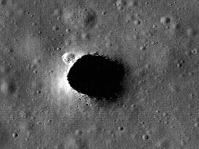
What was the velocity at impact for 13's SIVB? I wonder if there would be any identifiable debris in the bottom of the impact crater?
mikej Member
Posts: 257 From: Germantown, WI USA Registered: Jan 2004
posted March 31, 2010 08:17 AM
quote:Originally posted by hlbjr: What was the velocity at impact for 13's SIVB?
Posts: 2288 From: Sierra Vista, Arizona Registered: Nov 1999
posted May 25, 2010 11:19 AM
Galaxy Zoo has leveraged the LRO images to stand up its MOONZOO site: As announced by Galaxy Zoo:
It's been nearly 40 years seen Apollo astronaut Eugene Cernan became the last man to walk on the lunar surface, but at moonzoo.org/live you can take your own journey over lunar surface.
The site is powered by the efforts of visitors to Moon Zoo - the latest project from the team that brought you Galaxy Zoo and Solar Stormwatch. Using the site, you'll see images from NASA's Lunar Reconnaissance Orbiter which show the lunar surface in unprecedented detail, and with a few clicks you can record what you find while exploring.
Robert Pearlman Editor
Posts: 21917 From: Houston, TX Registered: Nov 1999
posted June 24, 2010 11:08 AM
Credit: NASA/Goddard
The Lunar Far Side: The Side Never Seen from Earth
Tidal forces between the moon and the Earth have slowed the moon' rotation so that one side of the moon always faces toward our planet. Though sometimes improperly referred to as the "dark side of the moon," it should correctly be referred to as the "far side of the moon" since it receives just as much sunlight as the side that faces us. The dark side of the moon should refer to whatever hemisphere isn't lit at a given time.
Though several spacecraft have imaged the far side of the moon since then, LRO is providing new details about the entire half of the moon that is obscured from Earth. The lunar far side is rougher and has many more craters than the near side, so quite a few of the most fascinating lunar features are located there, including one of the largest known impact craters in the solar system, the South Pole-Aitken Basin.
The image highlighted here shows the moon's topography from LRO's LOLA instruments with the highest elevations up above 20,000 feet in red and the lowest areas down below -20,000 feet in blue.
posted July 14, 2010 01:36 PM
I say: that's a future manned landing site!
NASA Science News: Newly-discovered pits on the Moon could be entrances to a geologic wonderland of underground caves and tunnels.
NASA's Lunar Reconnaissance Orbiter (LRO) is beaming back images of caverns hundreds of feet deep -- beckoning scientists to follow.
"They could be entrances to a geologic wonderland," says Mark Robinson of Arizona State University, principal investigator for the LRO camera. "We believe the giant holes are skylights that formed when the ceilings of underground lava tubes collapsed."
Japan's Kaguya spacecraft first photographed the enormous caverns last year. Now the powerful Lunar Reconnaissance Orbiter Camera (LROC, the same camera that photographed Apollo landers and astronauts' tracks in the moondust) is giving us enticing high-resolution images of the caverns' entrances and their surroundings.
Back in the 1960s, before humans set foot on the Moon, researchers proposed the existence of a network of tunnels, relics of molten lava rivers, beneath the lunar surface. They based their theory on early orbital photographs that revealed hundreds of long, narrow channels called rilles winding across the vast lunar plains, or maria. Scientists believed these rilles to be surface evidence of below-ground tunnels through which lava flowed billions of years ago.
"It's exciting that we've now confirmed this idea," says Robinson. "The Kaguya and LROC photos prove that these caverns are skylights to lava tubes, so we know such tunnels can exist intact at least in small segments after several billion years..."
Robert Pearlman Editor
Posts: 21917 From: Houston, TX Registered: Nov 1999
posted August 20, 2010 08:25 AM
NASA release
NASA's LRO Reveals 'Incredible Shrinking Moon'
Newly discovered cliffs in the lunar crust indicate the moon shrank globally in the geologically recent past and might still be shrinking today, according to a team analyzing new images from NASA's Lunar Reconnaissance Orbiter (LRO) spacecraft. The results provide important clues to the moon's recent geologic and tectonic evolution.
The moon formed in a chaotic environment of intense bombardment by asteroids and meteors. These collisions, along with the decay of radioactive elements, made the moon hot. The moon cooled off as it aged, and scientists have long thought the moon shrank over time as it cooled, especially in its early history. The new research reveals relatively recent tectonic activity connected to the long-lived cooling and associated contraction of the lunar interior.
"We estimate these cliffs, called lobate scarps, formed less than a billion years ago, and they could be as young as a hundred million years," said Dr. Thomas Watters of the Center for Earth and Planetary Studies at the Smithsonian's National Air and Space Museum, Washington. While ancient in human terms, it is less than 25 percent of the moon's current age of more than four billion years. "Based on the size of the scarps, we estimate the distance between the moon's center and its surface shrank by about 300 feet," said Watters, lead author of a paper on this research appearing in Science August 20.
"These exciting results highlight the importance of global observations for understanding global processes," said Dr. John Keller, Deputy Project Scientist for LRO at NASA's Goddard Space Flight Center, Greenbelt, Md. "As the LRO mission continues in to a new phase, with emphasis on science measurements, our ability to create inventories of lunar geologic features will be a powerful tool for understanding the history of the moon and the solar system."
The scarps are relatively small; the largest is about 300 feet high and extends for several miles or so, but typical lengths are shorter and heights are more in the tens of yards (meters) range. The team believes they are among the freshest features on the moon, in part because they cut across small craters. Since the moon is constantly bombarded by meteors, features like small craters (those less than about 1,200 feet across) are likely to be young because they are quickly destroyed by other impacts and don’t last long. So, if a small crater has been disrupted by a scarp, the scarp formed after the crater and is even younger. Even more compelling evidence is that large craters, which are likely to be old, don't appear on top any of the scarps, and the scarps look crisp and relatively undegraded.
Lobate scarps on the moon were discovered during the Apollo missions with analysis of pictures from the high-resolution Panoramic Camera installed on Apollo 15, 16, and 17. However, these missions orbited over regions near the lunar equator, and were only able to photograph some 20 percent of the lunar surface, so researchers couldn't be sure the scarps were not just the result of local activity around the equator. The team found 14 previously undetected scarps in the LRO images, seven of which are at high latitudes (more than 60 degrees). This confirms that the scarps are a global phenomenon, making a shrinking moon the most likely explanation for their wide distribution, according to the team.
As the moon contracted, the mantle and surface crust were forced to respond, forming thrust faults where a section of the crust cracks and juts out over another. Many of the resulting cliffs, or scarps, have a semi-circular or lobe-shaped appearance, giving rise to the term "lobate scarps". Scientists aren't sure why they look this way; perhaps it's the way the lunar soil (regolith) expresses thrust faults, according to Watters.
Lobate scarps are found on other worlds in our solar system, including Mercury, where they are much larger. "Lobate scarps on Mercury can be over a mile high and run for hundreds of miles," said Watters. Massive scarps like these lead scientists to believe that Mercury was completely molten as it formed. If so, Mercury would be expected to shrink more as it cooled, and thus form larger scarps, than a world that may have been only partially molten with a relatively small core. Our moon has more than a third of the volume of Mercury, but since the moon's scarps are typically much smaller, the team believes the moon shrank less.
Because the scarps are so young, the moon could have been cooling and shrinking very recently, according to the team. Seismometers emplaced by the Apollo missions have recorded moonquakes. While most can be attributed to things like meteorite strikes, the Earth's gravitational tides, and day/night temperature changes, it's remotely possible that some moonquakes might be associated with ongoing scarp formation, according to Watters. The team plans to compare photographs of scarps by the Apollo Panoramic Cameras to new images from LRO to see if any have changed over the decades, possibly indicating recent activity.
While Earth's tides are most likely not strong enough to create the scarps, they could contribute to their appearance, perhaps influencing their orientation, according to Watters. During the next few years, the team hopes to use LRO's high-resolution Narrow Angle Cameras (NACs) to build up a global, highly detailed map of the moon. This could identify additional scarps and allow the team to see if some have a preferred orientation or other features that might be associated with Earth's gravitational pull.
"The ultrahigh resolution images from the NACs are changing our view of the moon," said Dr. Mark Robinson of the School of Earth and Space Exploration at Arizona State University, Tempe, Ariz., a coauthor and Principal Investigator of the Lunar Reconnaissance Orbiter Camera. "We've not only detected many previously unknown lunar scarps; we're also seeing much greater detail on the scarps identified in the Apollo photographs."
The research was funded by NASA's Exploration Systems Mission Directorate at NASA Headquarters, Washington. The team includes researchers from the Smithsonian, Arizona State, the SETI Institute, Mountain View, Calif., NASA Ames Research Center, Moffett Field, Calif., Cornell University, Ithaca, N.Y., Institut für Planetologie, Westfälische Wilhelms-Universität, Münster, Germany, Brown University, Providence, R.I., and the Johns Hopkins University Applied Physics Laboratory, Laurel, Md.
robsouth Member
Posts: 542 From: West Midlands, UK Registered: Jun 2005
posted September 09, 2010 01:35 PM
I've noticed that this thread includes images taken from the LRO image browser. Is there a way to take shots from the photos posted on the LRO website?
Robert Pearlman Editor
Posts: 21917 From: Houston, TX Registered: Nov 1999
NASA's Lunar Reconnaissance Orbiter, or LRO, completed the exploration phase of its mission on Sept. 16, after a number of successes that transformed our understanding of Earth's nearest neighbor.
LRO completed a one-year exploration mission in a polar orbit approximately 31 miles above the moon's surface. It produced a comprehensive map of the lunar surface in unprecedented detail; searched for resources and safe landing sites for potential future missions to the moon; and measured lunar temperatures and radiation levels.
The mission is turning its attention from exploration objectives to scientific research, as program management moves from NASA's Exploration Systems Mission Directorate to the Science Mission Directorate at the agency's Headquarters in Washington.
"LRO has been an outstanding success. The spacecraft has performed brilliantly," said Doug Cooke, associate administrator of the Exploration Systems Mission Directorate. "LRO's science and engineering teams achieved all of the mission's objectives, and the incredible data LRO gathered will provide discoveries about the moon for years to come."
The LRO team will continue to send data gathered during the last year to the Planetary Data System, which archives and distributes scientific information from NASA planetary missions, astronomical observations and laboratory measurements.
By the time LRO achieves full mission success in March, and its data is processed and released to the scientific community, it will have sent more information to the Planetary Data System than all other previous planetary missions combined. During its new phase of discovery, LRO will continue to map the moon for two to four more years.
"The official start of LRO's science phase should write a new and intriguing chapter in lunar research," said Ed Weiler, associate administrator for the Science Mission Directorate. "This mission is one more asset added to NASA's vast science portfolio."
The spacecraft launched from NASA's Kennedy Space Center in Florida carrying a suite of seven instruments on June 18, 2009. LRO formally began its detailed survey of the moon in September 2009.
Results from the mission include: new observations of the Apollo landing sites; indications that permanently shadowed and nearby regions may harbor water and hydrogen; observations that large areas in the permanently shadowed regions are colder than Pluto; detailed information about lunar terrain; and the first evidence of a globally distributed population of thrust faults that indicates the moon has recently contracted and may still be shrinking.
LRO also took high resolution pictures of the Lunokhod 1 rover that had been lost for almost 40 years. The rover, which carries a retroreflector, was located to within approximately 150 feet. The accurate position data enabled researchers on Earth to bounce laser signals off the retroreflector for the first time ever. The retroreflector is providing important new information about the position and motion of the moon.
LRO also supported the Lunar Crater Observation and Sensing Satellite impact, a companion mission sent to determine if the moon's poles harbor water ice, by helping to select a promising impact site. LRO observed both the expanding plume that arose after the impact and the evolving temperature at the site.
NASA's Goddard Space Flight Center in Greenbelt, Md., built and manages LRO for the Exploration Systems Mission Directorate. The Institute for Space Research in Moscow provides the neutron detector aboard the spacecraft.
Jeff Member
Posts: 159 From: Fayetteville, NC, USA Registered: May 2009
posted October 22, 2010 10:33 PM
I was surfing the web tonight and stumble upon this video... thought the cS brethren would enjoy.
LM-12 Member
Posts: 80 From: Ontario, Canada Registered: Oct 2010
posted February 05, 2011 12:23 PM
The LROC Browse Gallery has just posted a great photo of the Apollo 14 landing site and Cone Crater. Most of the EVA tracks can clearly be seen. It's a nice way to mark the 40th anniversary of the moonwalk.
Robert Pearlman Editor
Posts: 21917 From: Houston, TX Registered: Nov 1999
posted March 15, 2011 04:57 PM
NASA release
NASA Lunar Reconnaissance Orbiter Delivers Treasure Trove Of Data
NASA's Lunar Reconnaissance Orbiter (LRO) team released Tuesday the final set of data from the mission's exploration phase along with the first measurements from its new life as a science satellite.
With this fifth release of data, striking new images and maps have been added to the already comprehensive collection of raw lunar data and high-level products, including mosaic images, that LRO has made possible. The spacecraft's seven instruments delivered more than 192 terabytes of data with an unprecedented level of detail. It would take approximately 41,000 typical DVDs to hold the new LRO data set.
"The release of such a comprehensive and rich collection of data, maps and images reinforces the tremendous success we have had with LRO in the Exploration Systems Mission Directorate and with lunar science," said Michael Wargo, chief lunar scientist of the Exploration Systems Mission Directorate at NASA Headquarters in Washington.
Among the latest products is a global map with a resolution of 100 meters per pixel from the Lunar Reconnaissance Orbiter Camera (LROC). To enhance the topography of the moon, this map was made from images collected when the sun angle was low on the horizon. Armchair astronauts can zoom in to full resolution with any of the mosaics -- quite a feat considering that each is 34,748 pixels by 34,748 pixels, or approximately 1.1 gigabytes.
"Because the moon is so close and because we have a dedicated ground station, we are able to bring back as much data from LRO as from all the other planetary missions combined," said LRO Project Scientist Richard Vondrak of NASA's Goddard Space Flight Center in Greenbelt, Md.
LRO's Diviner Lunar Radiometer Experiment is providing new data relating to the moon's surface. These include maps of visual and infrared brightness, temperature, rock abundance, nighttime soil temperature and surface mineralogy. The data are in the form of more than 1700 digital maps at a range of resolutions that can be overlaid easily on other lunar data sets.
The Lyman-Alpha Mapping Project, which collects information to help identify surface water-ice deposits, especially in permanently-shadowed regions of the moon, also has new data. This release includes new maps of far-ultraviolet (FUV) brightness, albedo and water-ice data as well as instrument exposure, illumination and other conditions.
As a complement to the high-resolution digital elevation maps, representing 3.4 billion measurements already released by the Lunar Orbiter Laser Altimeter team, the group is delivering new maps of slope, roughness and illumination conditions. New maps from the Lunar Exploration Neutron Detector, and the latest data from the Cosmic Ray Telescope for the Effects of Radiation and the Miniature Radio Frequency instruments, also are featured.
"All these global maps and other data are available at a very high resolution -- that's what makes this release exciting," said Goddard's John Keller, the LRO deputy project scientist. "With this valuable collection, researchers worldwide are getting the best view of the moon they have ever had."
The complete data set contains the raw information and high-level products such as mosaic images and maps. The data set also includes more than 300,000 calibrated data records released by LROC. All of the final records from the exploration phase, which lasted from Sept. 15, 2009 through Sept. 15, 2010, are available through several of the Planetary Data System nodes and the LROC website.


 posted September 06, 2009 12:22 PM