|
Author
|
Topic: NASA's Lunar Reconnaissance Orbiter (LRO)
|
gliderpilotuk
Member Posts: 2545
From: London, UK
Registered: Feb 2002
|
 posted July 19, 2009 01:50 PM
   
Not wishing to appear a skeptic  but I'm surprised at the length of the Apollo 11 LEM shadow. The descent stage was 3.2 metres high, but the shadow appears to be about 15 metres. Guess the Sun was very low! but I'm surprised at the length of the Apollo 11 LEM shadow. The descent stage was 3.2 metres high, but the shadow appears to be about 15 metres. Guess the Sun was very low! |
liftoff
Member Posts: 36
From: Watt, Switzerland
Registered: Jun 2008
|
posted July 20, 2009 02:36 AM
Wonderful pictures! When Apollo 11 landed, I was only four years old. Unfortunately, I have no memory of it. These fantastic images, therefore, give me the possibility to experience the historic moment of the first Apollo mission 40 years later.Congratulations to the team of the LRO mission for their great work! |
burnsnz
Member Posts: 66
From: Auckland, New Zealand
Registered: Jan 2004
|
posted July 20, 2009 02:29 PM
Pretty cool in the Apollo 11 image that you can see the narrow shadow of the Descent Engine Bell close to the landing site, then the wider shadow of the octagonal Descent stage further to the right. Re shadow length - you always get higher contrast images with low sun angles. I am pretty sure that all the landings occurred close to the local lunar dawn because of this as well. |
ilbasso
Member Posts: 1069
From: Reston, Virginia USA
Registered: Feb 2006
|
posted July 20, 2009 08:52 PM
quote:
Originally posted by gliderpilotuk:
I'm surprised at the length of the Apollo 11 LEM shadow. The descent stage was 3.2 metres high, but the shadow appears to be about 15 metres. Guess the Sun was very low!
Yes, check out the length of YOUR shadow at sunset sometime!The low sun angles provide shadows which accentuate the unevenness of the terrain. Look at pics of the full moon, when the sun is overhead. You can't tell anything about the high or low spots or the depth of craters. At low sun angles close to sunrise and sunset, all the details pop out. That's why we landed so close to sunrise. We didn't land close to sunset, because if something happened to delay the landing (like on Apollo 16) the landing site would be in darkness once night fell. |
Jurg Bolli
Member Posts: 436
From: Albuquerque, NM
Registered: Nov 2000
|
posted July 21, 2009 03:11 PM
Fabulous images, it makes me feel as if I am there on the moon. |
mark plas
Member Posts: 331
From: the Netherlands
Registered: Aug 2000
|
posted July 26, 2009 04:47 AM
Is that the S-band antenna next to Antares on the image of the Apollo 14 site? |
Paul Littler
Member Posts: 67
From: Brentwood, Essex, UK
Registered: Jul 2003
|
posted August 13, 2009 05:33 PM
Can someone advise when LRO will leave the commissioning orbit and get into the lower working orbit? |
Robert Pearlman
Editor Posts: 21917
From: Houston, TX
Registered: Nov 1999
|
posted August 13, 2009 06:01 PM
I don't have the exact date of it entering the mapping orbit (yet) but a news conference has been scheduled for August 27 to discuss "First Light" for LRO.
|
Scott
Member Posts: 3248
From: Houston, TX
Registered: May 2001
|
posted August 20, 2009 07:46 AM
New LRO image of the Apollo 14 landing site which includes Cone Crater (the bright crater halfway down, near the right edge of the image). |
Michael Davis
Member Posts: 291
From: Houston, Texas
Registered: Aug 2002
|
posted August 20, 2009 08:49 AM
Is there any definitive answer from this new image of Cone crater as to just how close Shepard and Mitchell got to the edge? Their trail seems to get too faint for me to see amide the jumble near the summit. |
mmmoo
Member Posts: 377
From: London, England
Registered: May 2001
|
posted August 20, 2009 09:30 AM
Here is a cropped view of Cone Crater. Click for a larger version.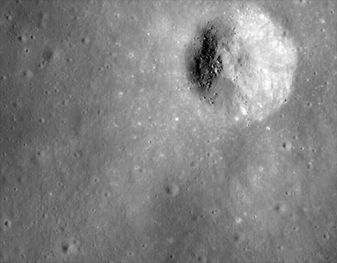 On the larger version you can just make out the trail of the astronauts to the bottom left. The trail seems to stop just close to a much smaller crater, below and left of Cone Crater |
spaced out
Member Posts: 2092
From: Paris, France
Registered: Aug 2003
|
posted August 20, 2009 09:59 AM
quote:
Originally posted by Michael Davis:
Is there any definitive answer from this new image of Cone crater as to just how close Shepard and Mitchell got to the edge?
The visible trail matches the traverse worked-out post-flight as shown on the Apollo 14 page of the Apollo Lunar Surface Journal.I believe Saddle Rock was the closest they came, and this is clearly visible in the image. |
Robert Pearlman
Editor Posts: 21917
From: Houston, TX
Registered: Nov 1999
|
posted August 20, 2009 10:26 AM
Space Coalition: Mystery Solved: New Apollo 14 Landing Site Imagery Released They ended up about 30 meters shy of peering into Cone crater itself, surely a disappointment at the time, but absolutely no reflection on the success of the traverse and the scientific results gleaned after the mission.The LRO camera imagery clearly shows that that the astronauts just barely missed the rim of Cone crater by less than 100 feet. "The fact that they did not look into the crater or return a photo of the inside of the crater in no way affected the science return of the mission," Robinson told this Coalition reporter. "Those guys did a really great job up there! I'd like to see the armchair critics out there do any better." |
Robert Pearlman
Editor Posts: 21917
From: Houston, TX
Registered: Nov 1999
|
posted August 20, 2009 12:21 PM
Lunar Reconnaissance Orbiter Camera (LROC) release Trail of Discovery at Fra MauroA month has already passed since LROC acquired its first images of the Apollo landing sites. In this time the Moon completed one rotation beneath LRO's orbit, thus providing another set of overflights. Because LRO is not in synch with the lunar day we see the same ground with different lighting -- this time the Sun is 24 degrees higher above the horizon providing a clearer view with fewer shadows. Albedo contrasts are greater, and more clearly show soil disturbances from landing, astronaut surface operations, and blast off. Apollo 14 Astronauts Alan Shepard and Edgar Mitchell explored the Fra Mauro highlands, which are composed of ejecta from the massive Imbrium impact. During two lunar surface extravehicular activities, Shepard and Mitchell deployed an Apollo Lunar Surface Experiments Package (ALSEP), tested the Modular Equipment Transporter (MET) -- a small wheeled cart used to transport samples and equipment) -- and collected almost 90 kg of invaluable lunar rock and soil. The ALSEP is visible about 180 meters west of the lunar module, note the well worn footpath connecting the two artifacts. During the second EVA, the astronauts performed what is known as a "radial traverse" across the ejecta field and up to the rim of Cone crater. When impact craters form, rocks excavated from the deepest parts of the crater fall near the rim; surface rocks end up away from the crater. Thus, as explorers move up a crater's ejecta blanket, they can sample a complete stratigraphic section of geologic materials providing priceless insights about the composition and nature of the lunar subsurface. Think of an impact crater as a natural roadcut exposing rocks from depth. In this LROC image, you can follow nearly the whole path walked by the two astronauts. The term "radial traverse" does not quite do the crew of Apollo 14 justice. Their journey sounds like a stroll in the park, however the reality is quite the contrary. The hike up Cone crater was quite challenging. For the first time, astronauts traveled out of the sight of their lunar module while hiking uphill over 1400 meters with only a poor map, dragging the tool cart (MET), and wearing their bulky spacesuits. It was an amazing feat that the two astronauts made it to the top of Cone ridge and acquired all their samples. They ended up about 30 meters shy of peering into Cone crater itself, surely a disappointment at the time, but absolutely no reflection on the success of the traverse and the scientific results gleaned after the mission. Fra Mauro was one of only two highlands sites to be visited during Project Apollo, and the samples collected at the Apollo 14 landing site continue to provide lunar scientists with important insights into the geology of the Moon. Nearly all of the Apollo 14 samples are breccias (or rocks formed from pieces of other rocks, often held together by an impact-melt matrix). Since the Fra Mauro formation is ejecta from the Imbrium basin-forming event, age-dating the samples returned by Shepard and Mitchell in terrestrial laboratories indicated that the Imbrium basin formed approximately 3.85 billion years ago, providing a crucial absolute age date for the formation of the Imbrium basin. Despite the momentous discoveries made by the Apollo 14 and Apollo 16 crews as they explored the highlands, there is still much we do not know. In particular, lunar scientists are eager to use the remote sensing data returned by the Lunar Reconnaissance Orbiter, Kaguya, and Chandrayaan-1 to look for evidence of highland rock types which may be underrepresented in the current Apollo sample collection. Since we only explored two highland locations located in close proximity, it is possible that there are highland rock types which have not yet been sampled. By identifying the location of any under-sampled rock types on the lunar surface using orbital data, the scientific results obtained by these new lunar scouts will help to determine the places on the Moon where we need to send future human explorers. 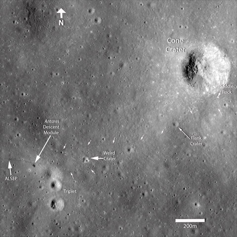 Annotated figure showing the positions of various landmarks surrounding the Apollo 14 landing site. The small white arrows highlight locations where the astronauts' path can be clearly seen. Click to enlarge. Credit: NASA/GSFC/Arizona State University |
4allmankind
Member Posts: 638
From: NJ
Registered: Jan 2004
|
posted August 20, 2009 01:22 PM
That image is absolutely unbelievable. Amazing detail... I am stunned.I am sure Ed Mitchell would love a view of it as well. |
spaced out
Member Posts: 2092
From: Paris, France
Registered: Aug 2003
|
posted August 20, 2009 01:44 PM
As the spacecraft makes other passes over the landing sites at different times of the lunar 'day' different sections of the various tracks on the surface will show up more or less clearly as the sun strikes the irregular lunar surface at various angles.Some parts of the Apollo 14 trails that don't show up too clearly on this shot will be more visible in later images. |
AstroAutos
Member Posts: 688
From: Monaghan Town, Co. Monaghan, Ireland
Registered: Mar 2009
|
posted August 20, 2009 02:20 PM
What an amzing photo.This Lunar Reconnaissance Orbiter certainly is doing it's job.. thanks for adding all these brilliant images guys! |
Dave Clow
Member Posts: 115
From: South Pasadena, CA 91030
Registered: Nov 2003
|
posted August 20, 2009 03:38 PM
Utterly amazing. |
tegwilym
Member Posts: 2186
From: Renton, WA USA
Registered: Jan 2000
|
posted August 21, 2009 04:47 PM
quote:
Originally posted by 4allmankind:
I am sure Ed Mitchell would love a view of it as well.
I want a copy of this photo signed by Ed! Now THAT would be cool.  When was the LRO going to be at it's final and lowest orbit? I thought it was sometime in October, but forget. These are just going to get better over time. Very, very, cool stuff! |
Robert Pearlman
Editor Posts: 21917
From: Houston, TX
Registered: Nov 1999
|
posted August 21, 2009 04:57 PM
quote:
Originally posted by tegwilym:
When was the LRO going to be at it's final and lowest orbit?
At the end of August; as mentioned earlier, there is a news conference set to discuss its first mapping image on August 27. |
Paul Littler
Member Posts: 67
From: Brentwood, Essex, UK
Registered: Jul 2003
|
posted August 22, 2009 06:43 AM
I am sure we all have a few friends who "wind us up" about the moon landings.I will enjoy showing my friends these photos but NASA said they would not waste a penny on proving the landings happened and this is not really what these photos are about. As the landing sites are the areas of the moon NASA knows more about than others am I not correct in believing that NASA want to find out if there are any "recent" craters that have arrived since the astronauts left? Then armed with that information NASA can calculate the risks of any bases or long term mission being hit. Has there been any work along these lines yet or is it too soon to say? |
Robert Pearlman
Editor Posts: 21917
From: Houston, TX
Registered: Nov 1999
|
posted August 22, 2009 07:26 AM
Impact rates are among the studies that will come from the Lunar Reconnaissance Orbiter data, but there is a much easier explanation for why NASA is imaging the landing sites: namely, the goal of the mission is to map as much of the Moon as possible, Apollo landing sites included.We currently have better maps of Mars than we do of the Moon. LRO is intended to correct that situation by providing an on-par surface guide to our nearest neighbor. |
robsouth
Member Posts: 542
From: West Midlands, UK
Registered: Jun 2005
|
posted August 22, 2009 08:22 AM
The images at the moment are taken vertically, any chance that some could be taken horizontally so that the landing path of the lunar module can be traced? |
Robert Pearlman
Editor Posts: 21917
From: Houston, TX
Registered: Nov 1999
|
posted August 22, 2009 10:54 AM
Though it is currently in an elliptical commissioning orbit, LRO will begin its primary mapping mission later this month after being placed into a circular polar orbit approximately 50 km above the Moon's surface. The LRO Camera (LROC) and other instruments are pointed downward toward the surface, such that they record the strip of land that passes below them. As such, all images taken by LRO will be captured in a north-south orientation. |
AstroAutos
Member Posts: 688
From: Monaghan Town, Co. Monaghan, Ireland
Registered: Mar 2009
|
posted August 22, 2009 04:23 PM
quote:
Originally posted by tegwilym:
I want a copy of this photo signed by Ed!
I agree, that would be cool. I think a nice inscription would be "Fra Mauro Base - The place I called home for a day..." |
cjh5801
Member Posts: 153
From: Tumwater
Registered: Jun 2009
|
posted August 22, 2009 05:35 PM
quote:
Originally posted by AstroAutos:
I think a nice inscription would be "Fra Mauro Base - The place I called home for a day..."
How about "Missed it by that much." |
Blackarrow
Member Posts: 1578
From: BELFAST, UNITED KINGDOM
Registered: Feb 2002
|
posted August 23, 2009 03:21 PM
quote:
Originally posted by Robert Pearlman:
The LRO camera imagery clearly shows that that the astronauts just barely missed the rim of Cone crater by less than 100 feet.
I remember reading in a 1971 news report (which I can't now find) that when the astronauts' photographs had been examined, and it became clear how close they had come to the edge of Cone Crater, someone in NASA told Shepard and Mitchell: "You weren't lost but you didn't know it!" |
Paul Littler
Member Posts: 67
From: Brentwood, Essex, UK
Registered: Jul 2003
|
posted August 23, 2009 04:13 PM
According to his website Ed Mitchell will sign photos mailed to him for $50 plus $5 for up to 10 words. It should be pretty easy to download the photo have it printed and then send it to him requesting inscriptions.I wonder if the photos in a few weeks from the mapping orbit will be worth waiting for? And hopefully there may be better shots of the other sites... |
Pat Gleeson
Member Posts: 38
From: Limerick, Ireland
Registered: Aug 2009
|
posted August 26, 2009 03:11 PM
quote:
Originally posted by 4allmankind:
I am sure Ed Mitchell would love a view of it as well.
Amazing indeed. I think Ed Mitchell would look at with some frustration also - man how close they were! Reading Andy Chaikin's 'Man on The Moon' gives you a great idea of how close they were too. This confirms just how close. |
DChudwin
Member Posts: 686
From: Lincolnshire IL USA
Registered: Aug 2000
|
posted August 29, 2009 09:22 PM
Some of the early Lunar Reconnaissance Orbiter Camera (LROC) pictures are now available on this website -- there are some amazingly detailed views of the Moon. |
ilbasso
Member Posts: 1069
From: Reston, Virginia USA
Registered: Feb 2006
|
posted August 29, 2009 10:34 PM
The Lunar Orbiter Imagery Recovery Project (LOIRP) has posted an excellent side-by-side comparison of the Apollo 14 landing site photos from Lunar Orbiter III (1967) and LROC. It's easy to see the effects of Apollo 14 on the landscape. |
Philip
Member Posts: 4360
From: Brussels, BELGIUM
Registered: Jan 2001
|
posted September 01, 2009 11:16 AM
The most amazing thing for me is the fact that the wheelbarrow Apollo 14 astronauts used, made such good tracks... |
Scott
Member Posts: 3248
From: Houston, TX
Registered: May 2001
|
posted September 03, 2009 12:36 PM
First look at the Apollo 12 landing site: 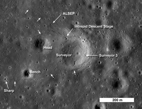
Credit: NASA/Goddard Space Flight Center/Arizona State University Apollo 12 and Surveyor 3Four months after the success of Apollo 11, NASA launched Apollo 12 in November 1969. Almost exactly 40 years later, the Lunar Reconnaissance Orbiter has seen the landing site. Engineering and safety constraints in place for these earliest manned lunar missions dictated landing Apollo 12 at an equatorial site on a flat lava plain (known as maria on the moon). NASA selected a site near where the unmanned Surveyor 3 had landed two years earlier, in western Oceanus Procellarum. Of course, landing within walking distance of the now inactive robotic lander (operational from April 20 to May 3, 1967) would prove pinpoint landing capability and allow the astronauts to return parts from the Surveyor for engineering assessment. The Surveyor 3 site also provided the opportunity to sample debris from the Copernicus crater impact, and what appeared from crater counts to be relatively young mare basalt. Astronauts Pete Conrad and Alan Bean piloted Intrepid to a landing within 200 meters of Surveyor 3 on Nov. 14, 1969. During their brief stay of almost 32 hours, the two astronauts performed two moonwalks, each a little less than four hours long. On the first moonwalk, they deployed an Apollo Lunar Surface Experiment Package (ALSEP), which returned scientific data directly to Earth for more than seven years. Next, the explorers headed to the northwest to collect soil and rock samples. In all they collected about about 15 kg (about 33 lbs) of lunar samples on this first excursion. The next day Conrad and Bean headed out on the first lunar geologic traverse. They traveled west, skirting around Head crater, then south to Bench crater. At both locations the astronauts collected rock and soil samples and photographed the interiors of the two craters. After Bench their furthest point (about 400 meters, or 437 yards) from the LM was Sharp crater. Their next goal was a rendezvous with the Surveyor 3 spacecraft, some 450 meters to the East. They extensively documented the condition of the Surveyor and collected hardware samples for terrestrial analysis, providing crucial data for present-day designers of lunar surface hardware. The Surveyor landed on the interior slope of what was later called Surveyor crater. There was some worry that as the astronauts removed parts for return to the Earth the spacecraft might slide downhill, so they always stayed up-slope. The iconic image of the Apollo astronaut examining the Surveyor with the LM in the background reminds us of the important role that both robots and humans can play in planetary exploration. In all, the Apollo 12 crew returned over 32 kg (more than 60 lbs) of lunar samples. From these precious samples scientists learned that the Copernicus crater impact occurred some 810 million years ago; four different types of local basalts were sampled with ages much younger than those from Apollo 11, and a small sample of highlands rock previewed the complexity of the lunar highlands to be sampled on later Apollo missions. All in all Apollo 12 was an incredible success. |
jimsz
Member Posts: 468
From:
Registered: Aug 2006
|
posted September 03, 2009 12:54 PM
Has the orbiter dropped to it's permanent lower orbit yet? |
Scott
Member Posts: 3248
From: Houston, TX
Registered: May 2001
|
posted September 03, 2009 04:00 PM
Not yet - I believe that will happen in mid-September. |
ilbasso
Member Posts: 1069
From: Reston, Virginia USA
Registered: Feb 2006
|
posted September 03, 2009 09:16 PM
I wish Pete Conrad were here to see those pictures. I wonder what he'd have to say? |
tegwilym
Member Posts: 2186
From: Renton, WA USA
Registered: Jan 2000
|
posted September 04, 2009 02:20 PM
quote:
Originally posted by ilbasso:
I wish Pete Conrad were here to see those pictures. I wonder what he'd have to say?
"Whoooopie!" |
DChudwin
Member Posts: 686
From: Lincolnshire IL USA
Registered: Aug 2000
|
posted September 04, 2009 06:48 PM
It is amazing how well 40 years later you can see the tracks of Conrad and Bean on the surface, including some near Surveyor. Footprints last a long time when there is no wind or atmosphere. |
cjh5801
Member Posts: 153
From: Tumwater
Registered: Jun 2009
|
posted September 05, 2009 04:54 PM
If it's any consolation to Alan Bean, the above photo makes it clear that much of the crew's activities on the lunar surface would have been out of the stationary TV camera's range anyway. |
FFrench
Member Posts: 2902
From: San Diego
Registered: Feb 2002
|
posted September 05, 2009 06:56 PM
quote:
Originally posted by ilbasso:
I wish Pete Conrad were here to see those pictures. I wonder what he'd have to say?
I had a very nice opportunity to talk to Al Bean about the image the day after it was released, as he is here at the museum... he seems to have just as much of a sense of wonder as anyone to see his own footprints still there forty years later. It's a powerful image.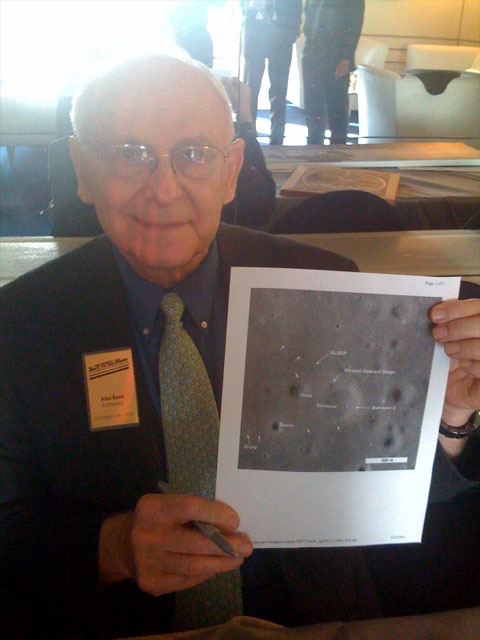 |


