|
|

|
|
Author
|
Topic: GeoEye-1 commercial Earth-imaging satellite
|
Robert Pearlman
Editor Posts: 42988
From: Houston, TX
Registered: Nov 1999
|
 posted 09-05-2008 10:57 PM
   
GeoEye release
GeoEye to Launch World's Highest Resolution Commercial Earth-Imaging Sat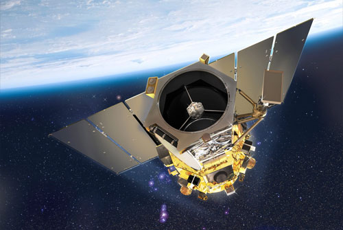
GeoEye, Inc., a premier provider of satellite, aerial and geospatial information, announced today the launch of the world's highest resolution, commercial Earth-imaging satellite is scheduled for Sept. 6, 2008, from Space Launch Complex-2 at Vandenberg Air Force Base (VAFB), California. The planned launch time is 11:50:57 a.m. PDT (2:50:57 p.m. EDT).GeoEye-1 will be lifted into a near-polar orbit by a 12-story-tall United Launch Alliance Delta II 7420-10 configuration launch vehicle. The launch vehicle and associate support services were procured by Boeing Launch Services. The Delta II rocket is expected to deploy the GeoEye-1 spacecraft approximately 58 minutes after liftoff and the Company expects to establish first contact about 90 minutes after launch. In order to achieve the proper orbit, the launch window will only be open for 84 seconds. Once in orbit, GeoEye-1 will undergo system calibration and testing. The company expects to offer imagery and products to customers in the mid- to late-October timeframe. The GeoEye-1 Satellite GeoEye-1, designed and built by General Dynamics Advanced Information Systems, is the world's highest resolution commercial imaging satellite. Designed to take color images of the Earth from 423 miles (681 kilometers) in space and moving at a speed of about four-and-a-half miles (seven kilometers) per second, the satellite will make 15 earth orbits per day and collect imagery with its ITT-built imaging system that can distinguish objects on the Earth's surface as small as 0.41-meters (16 inches) in size in the panchromatic (black and white) mode. The 4,300-pound satellite will also be able to collect multispectral or color imagery at 1.65-meter ground resolution. While the satellite will be able to collect imagery at 0.41-meters, GeoEye's operating license from NOAA requires re-sampling the imagery to half-meter resolution for all customers not explicitly granted a waiver by the U.S. Government. The satellite will be able to see an object the size of home plate on a baseball diamond but also map the location of an object that size to within about nine feet (three meters) of its true location on the surface of the Earth without need for ground control points. Together, GeoEye's IKONOS and GeoEye-1 satellites can collect almost one million square kilometers of imagery per day. With the ability to revisit any location on the globe every three days, and at lesser resolution more frequently, GeoEye-1 will enable customers to receive imagery updates on a regular basis and is ideal for large-scale mapping projects. This capability will benefit a broad array of industries including national defense and intelligence, online mapping, state and local governments, environmental monitoring and land use management, oil and gas, utilities, disaster management, insurance and others. Watch 'Live' on the Internet The launch video and commentary will be streamed 'live' over the Internet beginning at about 11:15 a.m. PDT after feeding 15 minutes of bars and tone. The live Web broadcast can be accessed by visiting the GeoEye Web site or by going directly here. Boeing's webcast of the launch may be found at here. |
Robert Pearlman
Editor Posts: 42988
From: Houston, TX
Registered: Nov 1999
|
posted 09-05-2008 11:16 PM
CNET: Google to buy GeoEye satellite imagery Google has signed a deal under which GeoEye will supply the search giant with imagery from a satellite due to launch in coming days, the companies said. Under the deal, Google is the exclusive online mapping site that may use the imagery, said Mark Brender, vice president of corporate communications and marketing. Google uses satellite imagery in its Google Maps and Google Earth product. And as a little icing on the cake, Google's logo is on the side of the rocket set to launch the 4,300-pound satellite in six days from Vandenberg Air Force Base in California. Terms of the deal weren't disclosed. |
Robert Pearlman
Editor Posts: 42988
From: Houston, TX
Registered: Nov 1999
|
posted 09-06-2008 05:28 PM
GeoEye release
GeoEye-1 Satellite Launches Into Space From Vandenberg Air Force Base, California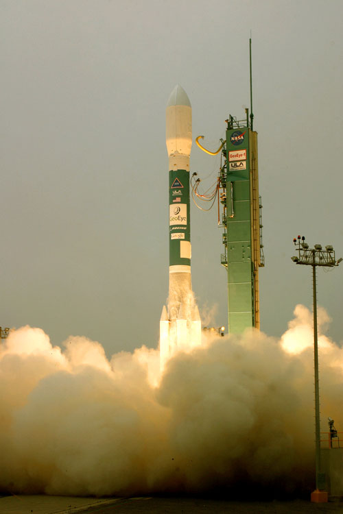
An United Launch Alliance Delta II rocket, on behalf of Boeing Launch Services, blasts off today at 11:50.57 a.m. PDT with the GeoEye-1 satellite from Space Launch Complex-2 at Vandenberg Air Force Base, Calif. The successful launch concluded approximately 75 minutes later with signal acquisition from the satellite in its proper orbit. Photo by Carleton Bailie, The Boeing Company GeoEye, Inc., a premier provider of satellite, aerial and geospatial information, announced today the successful launch and deployment of GeoEye-1, the world's highest resolution, commercial Earth-imaging satellite.GeoEye's ground station in Norway relayed the downlink signal it received from GeoEye-1 confirming that the satellite successfully separated from the second stage of the launch vehicle and began automatically initializing its onboard systems. Bill Schuster, GeoEye chief operating officer, said, "Based upon the data we saw, the satellite is performing properly and ready to begin the next phase towards meeting its mission requirements." GeoEye-1 will now undergo a calibration and check-out period before imagery products will be available for sale. Matthew O'Connell, GeoEye chief executive officer, said, "Later this fall, we will start providing high-resolution color imagery of the Earth from our newest satellite to customers around the globe. The imagery from GeoEye-1 adds to the quantity and quality of that currently provided by our IKONOS satellite, and together this magnificent constellation will enable us to meet world-wide customer demand." O'Connell added, "This launch, and our important relationship with the National Geospatial-Intelligence Agency (NGA), shows how public-private partnerships can be successful for the collection of broad areas of the Earth. And all our customers can be assured of continued access to quality products and first-class customer service." GeoEye-1 is part of the NGA NextView program. The NextView program is designed to ensure that the NGA has access to commercial imagery in support of its mission to provide timely, relevant and accurate geospatial intelligence in support of national security. GeoEye won its $500-million NextView contract in September 2004 and was able to build and launch GeoEye-1 without any contract cost overruns in less than four years after contract award. GeoEye-1 will simultaneously collect 0.41-meter ground resolution black-and-white (panchromatic) images and 1.65-meter color (multispectral) images. Designed to take digital images of the Earth from 423 miles (681 kilometers) and moving at a speed of about four-and-a-half miles (seven kilometers) per second, the satellite camera can distinguish objects on the Earth's surface as small as 0.41-meter or 16 inches in size. Due to U.S. licensing restrictions, commercial customers will get access to imagery at half-meter ground resolution. GeoEye-1 was built by General Dynamics Advanced Information Systems in Gilbert, Ariz. The imaging system was built by ITT in Rochester, NY. ITT is also building the imaging system for GeoEye-2 slated for launch in 2011. The 4310-pound satellite was launched at 11:50 a.m. PDT on a United Launch Alliance Delta II rocket from Vandenberg Air Force Base in California. The launch of GeoEye-1 marks the 83rd consecutive successful launch of the Delta II rocket. |
ejectr
Member Posts: 1751
From: Killingly, CT
Registered: Mar 2002
|
posted 09-06-2008 05:51 PM
Why Vandenberg? Polar orbit? |
Robert Pearlman
Editor Posts: 42988
From: Houston, TX
Registered: Nov 1999
|
posted 09-06-2008 06:05 PM
quote:
Originally posted by ejectr:
Why Vandenberg? Polar orbit?
Yes, GeoEye-1 is in a near polar orbit at an inclination of 98 degrees. |
Ben
Member Posts: 1896
From: Cape Canaveral, FL
Registered: May 2000
|
posted 09-06-2008 07:26 PM
quote:
Originally posted by ejectr:
Why Vandenberg? Polar orbit?
Only in a polar orbit can you image the entire earth, which is what this spacecraft is designed to do. | |
Contact Us | The Source for Space History & Artifacts
Copyright 2020 collectSPACE.com All rights reserved.

Ultimate Bulletin Board 5.47a
|
|
|
 advertisement advertisement
|


