Space News
space history and artifacts articles

Messages
space history discussion forums

Sightings
worldwide astronaut appearances

Resources
selected space history documents

  collectSPACE: Messages
  Space Shuttles - Space Station
  Earth science instruments on space station

Post New Topic  Post A Reply
profile | register | preferences | faq | search

next newest topic | next oldest topic
Author Topic:   Earth science instruments on space station
Robert Pearlman
Editor

Posts: 42988
From: Houston, TX
Registered: Nov 1999

posted 09-08-2014 07:56 PM     Click Here to See the Profile for Robert Pearlman   Click Here to Email Robert Pearlman     Edit/Delete Message   Reply w/Quote
NASA release
NASA Launches New Era of Earth Science from Space Station

The launch of a NASA ocean winds sensor to the International Space Station (ISS) this month inaugurates a new era of Earth observation that will leverage the space station's unique vantage point in space. Before the end of the decade, six NASA Earth science instruments will be mounted to the station to help scientists study our changing planet.

The first NASA Earth-observing instrument to be mounted on the exterior of the space station will launch from Cape Canaveral Air Force Station, Florida, on the next SpaceX Commercial Resupply Services flight, currently targeted for no earlier than Sept. 19. ISS-RapidScat will monitor ocean winds for climate research, weather predictions and hurricane monitoring from the space station.

The second instrument is the Cloud-Aerosol Transport System (CATS), a laser instrument that will measure clouds and the location and distribution of airborne particles such as pollution, mineral dust, smoke, and other particulates in the atmosphere. CATS will follow ISS-RapidScat on the fifth SpaceX space station resupply flight, targeted for December.
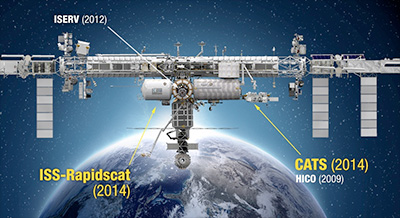
"We're seeing the space station come into its own as an Earth-observing platform," said Julie Robinson, chief scientist for the International Space Station Program at NASA's Johnson Space Center in Houston. "It has a different orbit than other Earth remote sensing platforms. It's closer to Earth, and it sees Earth at different times of day with a different schedule. That offers opportunities that complement other Earth-sensing instruments in orbit today."

The space station-based instruments join a fleet of 17 NASA Earth-observing missions currently providing data on the dynamic and complex Earth system. ISS-RapidScat and CATS follow the February launch of the Global Precipitation Measurement Core Observatory, a joint mission with the Japan Aerospace Exploration Agency, and the July launch of the Orbiting Carbon Observatory-2, making 2014 one of the busiest periods for new NASA Earth science missions in more than a decade.

Most of the agency's free-flying, Earth-observing satellites orbit the planet over the poles at altitudes higher than 400 miles in order to gather data from all parts of the planet. Although the space station does not pass over Earth's polar regions, its 240-mile high orbit does offer logistical and scientific advantages.

"With the space station we don't have to build a spacecraft to gather new data -- it's already there," said Stephen Volz, associate director of flight programs in the Earth Science Division at NASA Headquarters in Washington. "The orbit enables rare, cross-disciplinary observations when the station flies under another sensor on a satellite. Designing instruments for the space station also gives us a chance to do high-risk, high-return instruments in a relatively economical way."

The data provided by ISS-RapidScat will support weather and marine forecasting, including tracking storms and hurricanes. The station's orbit will allow the instrument to make repeated, regular observations over the same locations at different times of day, providing the first near-global measurements of how winds change throughout the day. ISS-RapidScat was built by NASA's Jet Propulsion Laboratory (JPL) in Pasadena, California.

CATS is a laser remote-sensing instrument, or lidar, that measures clouds and tiny aerosol particles in the atmosphere. These atmospheric components play a critical part in understanding how human activities such as pollution and fossil fuel burning contribute to climate change. CATS was built by NASA's Goddard Space Flight Center in Greenbelt, Maryland.

Two additional NASA Earth science instruments are scheduled to launch to the station in 2016. The Stratospheric Aerosol and Gas Experiment III (SAGE III), will measure aerosols, ozone, water vapor and other gases in the upper atmosphere to help scientists assess how the ozone layer is recovering and better understand global climate change. SAGE III was developed by NASA's Langley Research Center in Hampton, Virginia, and built by Ball Aerospace of Boulder, Colorado.

The Lightning Imaging Sensor (LIS) will detect and locate lightning over tropical and mid-latitude regions of the globe. The first LIS was launched in 1997 as part of NASA's Tropical Rainfall Measuring Mission. The sensor will monitor lightning for Earth science studies and provide cross-sensor calibration and validation with other space-borne instruments and ground-based lightning networks. LIS was developed by NASA's Marshall Space Flight Center in Huntsville, Alabama.

In July, NASA selected proposals for two new instruments that will observe changes in global vegetation from the space station, giving scientists new ways to observe how forests and ecosystems are affected by changes in climate and land use change. Both sensors will be completed before the end of the decade.

The Global Ecosystem Dynamics Investigation (GEDI) will use a laser-based system to study forest canopy structure in a range of ecosystems, from the tropics to the high northern latitudes. The observations will help scientists better understand the changes in carbon storage within forests from both human activities and natural climate variations. GEDI is managed by scientists at the University of Maryland, College Park.

The ECOsystem Spaceborne Thermal Radiometer Experiment on Space Station (ECOSTRESS) is a high-resolution multiple wavelength thermal imaging spectrometer that will study water use and water stress in vegetation. Measurements of the loss of water from growing leaves and evaporation from the soil will help reveal how ecosystems change with climate and provide a critical link between the water cycle and plant health in both natural and agricultural ecosystems. ECOSTRESS is managed by JPL.

The space station provides several capabilities useful to both instruments. The space station orbit provides more observation time of forests and vegetation over temperate land masses than possible with the polar orbit commonly used for other types of Earth observations. The GEDI laser requires significant power resources, which the space station can provide.

Robert Pearlman
Editor

Posts: 42988
From: Houston, TX
Registered: Nov 1999

posted 11-28-2016 04:28 PM     Click Here to See the Profile for Robert Pearlman   Click Here to Email Robert Pearlman     Edit/Delete Message   Reply w/Quote
NASA release
NASA's ISS-RapidScat Earth Science Mission Ends

NASA's International Space Station Rapid Scatterometer (ISS-RapidScat) Earth science instrument has ended operations following a successful two-year mission aboard the space station. The mission launched Sept. 21, 2014, and had recently passed its original decommissioning date.

ISS-RapidScat used the unique vantage point of the space station to provide near-real-time monitoring of ocean winds, which are critical in determining regional weather patterns. Its measurements of wind speed and direction over the ocean surface have been used by agencies worldwide for weather and marine forecasting and tropical cyclone monitoring. Its location on the space station made it the first space-borne scatterometer that could observe how winds evolve throughout the course of a day.

"As a first-of-its-kind mission, ISS-RapidScat proved successful in providing researchers and forecasters with a low-cost eye on winds over remote areas of Earth's oceans," said Michael Freilich, director of NASA's Earth Science Division. "The data from ISS-RapidScat will help researchers contribute to an improved understanding of fundamental weather and climate processes, such as how tropical weather systems form and evolve."

The agencies that routinely used ISS-RapidScat's data for forecasting and monitoring operations include the National Oceanic and Atmospheric Administration (NOAA) and the U.S. Navy, along with European and Indian weather agencies. It provided more complete coverage of wind patterns far out to sea that could build into dangerous storms. Even if these storms never reach land, they can bring devastating wave impacts to coastal areas far away.

"The unique coverage of ISS-RapidScat allowed us to see the rate of change or evolution in key wind features along mid-latitude storm tracks, which happen to intersect major shipping routes," said Paul Chang, Ocean Surface Winds Science team lead at NOAA's Center for Satellite Applications and Research. "ISS-RapidScat observations improved situational awareness of marine weather conditions, which aid optimal ship routing and hazard avoidance, and marine forecasts and warnings."

During its mission, ISS-RapidScat also provided new insights into research questions such as how changing winds over the Pacific drove changes in sea surface temperature during the 2015-2016 El Niño event. Due to its unique ability to sample winds at different times of day, its data will be useful to scientists for years to come.

ISS-RapidScat was born out of ingenuity, expertise and a need for speed. It was constructed in less than two years to replace its widely valued predecessor, NASA's decade-old QuikScat scatterometer satellite, at a fraction of the cost of the original – largely by adapting spare parts from QuikScat.

On Aug. 19, a power distribution unit for the space station's Columbus module failed, resulting in a power loss to ISS-RapidScat. Later that day, as the mission operations team from NASA's Jet Propulsion Laboratory (JPL) in Pasadena, California, attempted to reactivate the instrument, one of the outlets on the power distribution unit experienced an electrical overload. In the following weeks, multiple attempts to restore ISS-RapidScat to normal operations were not successful, including a final attempt on Oct. 17.

NASA currently does not plan to launch another scatterometer mission. However, the loss of ISS-RapidScat data will be partially mitigated by the newly launched ScatSat ocean wind sensor, a mission of the Indian Space Research Organization.

ISS-RapidScat was the first continuous Earth-observing instrument specifically designed and developed to operate on the International Space Station exterior, but it's no longer the only one. The Cloud-Aerosol Transport System (CATS) joined the space station in January 2015 to provide cost-effective measurements of atmospheric aerosols and clouds in Earth's atmosphere. Two more instruments are scheduled to launch to the space station in 2017 – one that will allow scientists to monitor the ozone layer's gradually improving health, and another to observe lightning over Earth's tropics and mid-latitudes. Following that, two additional Earth science instruments are scheduled for launch in 2018 and 2019.

ISS-RapidScat was a partnership between JPL and the International Space Station Program Office at NASA's Johnson Space Center in Houston, with support from the Earth Science Division of NASA's Science Mission Directorate in Washington. Other mission partners include the agency's Kennedy Space Center in Florida and its Marshall Space Flight Center in Huntsville, Alabama; the European Space Agency; and SpaceX.

NASA collects data from space, air, land and sea to increase our understanding of our home planet, improve lives and safeguard our future. NASA develops new ways to observe and study Earth's interconnected natural systems with long-term data records. The agency freely shares this unique knowledge and works with institutions around the world to gain new insights into how our planet is changing.

All times are CT (US)

next newest topic | next oldest topic

Administrative Options: Close Topic | Archive/Move | Delete Topic
Post New Topic  Post A Reply
Hop to:

Contact Us | The Source for Space History & Artifacts

Copyright 2020 collectSPACE.com All rights reserved.


Ultimate Bulletin Board 5.47a


advertisement