|
Author
|
Topic: Topography of the Apollo 11 landing site
|
Buel
Member Posts: 726
From: UK
Registered: Mar 2012
|
 posted 12-27-2020 01:29 AM
   
Does anyone know of the best method or route to get the topography of Mare Tranquillitatis, the Apollo 11 landing site, to include as much detail as possible? |
MCroft04
Member Posts: 1701
From: Smithfield, Me, USA
Registered: Mar 2005
|
posted 12-27-2020 08:10 AM
Some of the geologic maps I have include topography, but with somewhat limited detail. I don't have an Apollo 11 landing site geologic map (it would be pretty boring). It was also pretty flat.I remember having Charlie Duke sign my geologic map for Apollo 16, and when he saw the contours he wanted to know what their landing elevation was. The map was a bit hard to read but I eventually was able to answer — somewhere around 15000 feet, I think. He responded in that Carolina drawl of his; "I've been telling everybody it was fiiiiive thousand feet!"  |
Headshot
Member Posts: 968
From: Vancouver, WA, USA
Registered: Feb 2012
|
posted 12-27-2020 10:01 AM
I would check out the Lunar and Planetary Institute, and Lunar and Planetary Laboratory websites for maps. Possibly the United States Geological Survey website too. |
GACspaceguy
Member Posts: 2650
From: Guyton, GA
Registered: Jan 2006
|
posted 12-27-2020 02:07 PM
So if AP-16 landed at 15,000' what is the zero foot reference? |
oly
Member Posts: 1146
From: Perth, Western Australia
Registered: Apr 2015
|
posted 12-27-2020 04:45 PM
The lunar module was equipped with a radar altimeter that measures the distance from the lunar surface to the lunar module altimeter receiver antenna array. This provides information of height above the ground. The lunar surface contact probes fitted to three of the four landing legs provided information about the distance from the landing gear foot pad and the lunar surface. |
Robert Pearlman
Editor Posts: 45454
From: Houston, TX
Registered: Nov 1999
|
posted 12-27-2020 06:00 PM
quote:
Originally posted by Buel:
...topography of Mare Tranquillitatis
The Lunar Reconnaissance Orbiter Camera (LROC) website has digital terrain models for the Apollo 11 landing site, which may be what you are seeking (or help point you to the data set you need). |
Andy Anderson
Member Posts: 96
From: Perth, Australia
Registered: Dec 2009
|
posted 12-27-2020 06:49 PM
The Apollo 11 Mission Report, page 5-28, figure 5-9 "Terrain Indicated By Landing Radar", shows the radar altimeter plot as mentioned by Oly and page 5-29, figure 5-10 "Basic Lunar Reference Map", depicts the area around and to the East of the landing site with contours and spot elevations.You can find a good copy of that report here: Virginia Tech - Apollo 11 Mission Report - Michael Collins Copy. |
MCroft04
Member Posts: 1701
From: Smithfield, Me, USA
Registered: Mar 2005
|
posted 12-27-2020 08:03 PM
quote:
Originally posted by GACspaceguy:
So if AP-16 landed at 15,000' what is the zero foot reference?
Good question. Obviously its not sea level. I'll go back to my geologic maps to see if I can find what the reference was. |
oly
Member Posts: 1146
From: Perth, Western Australia
Registered: Apr 2015
|
posted 12-27-2020 09:37 PM
"Zero foot reference" is derived from data received by the landing radar and the radar altimeter, with a cross-check between the two carried out at high gate/pitchover, for Apollo 11 this occurred at 7129 feet above the lunar surface with a rate of descent of 125 ft/sec.The altitude difference between that calculated by the onboard computer and that determined by the landing radar was approximately 2800 feet, which agrees with the altitude error suspected from the Doppler residual comparison. Radar altitude updates of the onboard computer were enabled at 102:38:45 MET, and the differences converged within 30 seconds. There is a graph depicting radar altimeter data during the landing phase (as referenced by Andy) which shows a change in indicated altitude as the Apollo 11 LM overflew a large crater, however, at this stage Armstrong was eyeballing the lunar surface and listening to Aldrin call out the numbers. The "zero foot reference" had changed from radar altimeter data to visual references (one reason why the approach was flown with a low, up sun angle), the crew reported that dust became visible at approx. 100 ft AGL. Note that the Apollo 11 landing site was below the mean lunar radius. Topographic maps of the landing site were for reference only, as the true surface detail was not well known enough for accurate terrain avoidance. quote:
Originally posted by MCroft04:
I'll go back to my geologic maps to see if I can find what the reference was.
The use of geologic maps would be useless for spacecraft landing reference unless you wanted to land at the site of a specific type of rock or surficial deposit, or perhaps a geologic structure such as a fault or fold. |
moorouge
Member Posts: 2482
From: U.K.
Registered: Jul 2009
|
posted 12-28-2020 07:57 AM
I've had to dust down my copy of the 1975 edition of Manned Spaceflight for the answer.The highest Apollo landing was Apollo 16 at 7830 metres. This is measured relative to a sphere of radius 1,738,000 metres, which in 1975 at any rate, was how heights on the Moon were measured. |
David C
Member Posts: 1218
From: Lausanne
Registered: Apr 2012
|
posted 12-28-2020 10:15 AM
quote:
Originally posted by oly:
"Zero foot reference" is derived from data received by the landing radar and the radar altimeter ... Note that the Apollo 11 landing site was below the mean lunar radius.Topographic maps of the landing site were for reference only, as the true surface detail was not well known enough for accurate terrain avoidance.
I think you’re confusing two questions here. The flying question, to over-simplify "coming down to rad alt zero," and the more general question of landing site elevation. They have different zero references. You're basically correct on the rad alt. However landing site elevation is not irrelevant. That is measured with respect to the selenic geodetic zero rather than sea level. Back during Αpollo I think they used a reference radius of 1738 kilometres. Today I think they’ve revised it to 1737.4 km. I'm no expert, so another I think, that's based on center of lunar figure rather than center of gravity. |
One Big Monkey
Member Posts: 174
From: West Yorkshire, UK
Registered: Jul 2012
|
posted 12-28-2020 12:30 PM
The 3D models you can generate from the LRO quickmap site are OK, but you can make much more detailed ones from DEM models available elsewhere on the LRO site, e.g. here. You'll need software capable of rendering it into 3D. I use QGIS, which has a 3D plugin and is free, and you should be able to get relative heights and so on from the DTM layer. To be honest, the Apollo 11 terrain is probably the least interesting of all the missions! Here's a 3D view I made using QGIS. 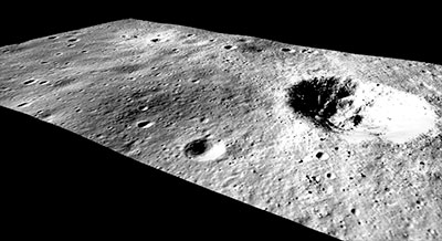 |
MCroft04
Member Posts: 1701
From: Smithfield, Me, USA
Registered: Mar 2005
|
posted 12-28-2020 03:45 PM
quote:
Originally posted by David C:
They have different zero references.
Dave, thanks for answering my question. Makes sense. |
Buel
Member Posts: 726
From: UK
Registered: Mar 2012
|
posted 12-29-2020 10:24 AM
quote:
Originally posted by One Big Monkey:
...you can make much more detailed ones from DEM models available elsewhere on the LRO site
This is great, thanks so much. Can you please email me so we can discuss further (can't see your email, only the brilliant website). |
jklier
Member Posts: 64
From: Austin, Texas
Registered: Aug 2007
|
posted 01-21-2021 01:05 PM
quote:
Originally posted by One Big Monkey:
...the Apollo 11 terrain is probably the least interesting of all the missions!
You are absolutely right about that. I 3D printed a number of models of the landing sites from DTMs I rendered. Apollo 11 is just a flat bit of nothing compared to the later missions. Definitely a much safer place to try the first landing! |


