Astrolab's FLIP rover joins Astrobotic's Griffin-1 to the MoonToday (Feb. 5), Venturi Astrolab (Astrolab) and Astrobotic announced that Astrobotic's Griffin lander will deliver an Astrolab rover to the Moon as part of Astrobotic's Griffin Mission One (Griffin-1). The rover, currently known as FLIP (FLEX Lunar Innovation Platform), will be deployed at the Nobile Region of the lunar south pole.
The Astrobotic mission, originally carrying the VIPER payload as part of NASA's Commercial Lunar Payload Services (CLPS) initiative, is scheduled for delivery at the end of 2025.
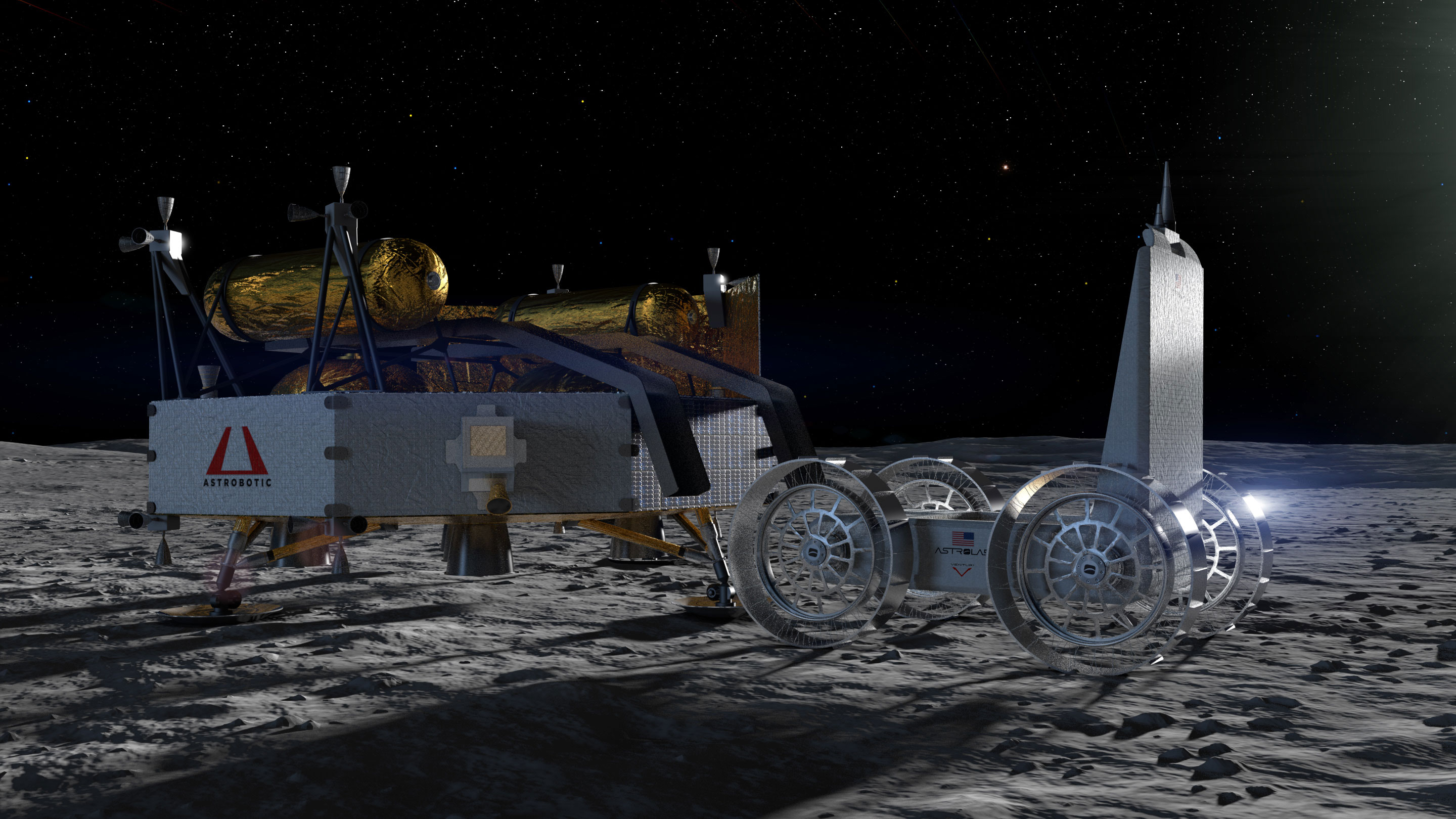
Above: A rendering of Astrolab's FLIP rover fully deployed from Astrobotic's Griffin-1 lander on the lunar surface.
"Astrobotic received worldwide interest from dozens of organizations eager to fly aboard Griffin-1, and we conducted a rigorous selection process to identify the mission partner that aligned best with our timeline and Griffin's capabilities. Astrolab shares our vision of making lunar science, exploration, and commercial activity both accessible and transformative. By deploying the FLIP rover on Griffin-1, we are advancing humanity's future on the Moon and enabling groundbreaking U.S. technology demonstrations at the lunar South Pole," says John Thornton, Astrobotic's founder and CEO.
Astrobotic is at the forefront of making the Moon accessible to the world as a leading provider of lunar transportation, mobility, and power. In July, NASA announced its intent to discontinue the VIPER (Volatiles Investigating Polar Exploration Rover) project due to funding constraints, future budget risks, and lander delays. The NASA CLPS contract to deliver VIPER to the Moon has been modified to serve as a large lander demonstration flight.
Astrobotic's Griffin lander will demonstrate this capability and fly a similar mass load as VIPER to the South Pole region of the Moon. To help achieve this goal, Astrobotic's Griffin lander will deploy Astrolab's FLIP rover on the Moon. FLIP will demonstrate core components and subsystems used on the company's large-scale vehicle, the Flexible Logistics and Exploration (FLEX) rover, introduced in 2022.
"By joining Griffin Mission One, we will gather key insights into how lunar rovers like FLIP and FLEX operate in real lunar conditions," said Jaret Matthews, founder and CEO, Astrolab. "Bringing FLIP to the Moon offers an opportunity to demonstrate and test many of the critical technologies that will advance the commercial FLEX vehicle, including full-sized batteries, tires, critical avionics systems, sensors, and software."
In 2023, Astrolab announced an agreement with SpaceX to land the commercial FLEX rover on the Moon as soon as December 2026. SpaceX will transport FLEX to the lunar surface using its Starship launch and landing system, and Astrolab has agreed to a two-year launch window with SpaceX. The FLIP platform provides an opportunity not only to mature technologies for the core FLEX platform but also to enable the acquisition of critical science data prior to this commercial mission.
"Losing VIPER could've been a setback, but Astrobotic didn't let up. They rolled up their sleeves, found a new way forward, and made sure this mission stays on track. With Astrolab's FLIP rover onboard, we're showing the world that when challenges come our way, we double down," said John Fetterman, U.S. Senator for Pennsylvania.
"This is how we lead—not by playing it safe but by pushing forward with the technology that'll shape the future of exploration. I couldn't be prouder that Pennsylvania's Astrobotic is making sure America stays first in line to the lunar South Pole," Fetterman said.
Additional background on the FLIP rover
Last year, Astrolab, together with its partner Venturi Space, unveiled a development prototype of the FLIP rover at the 75th International Astronautical Congress in Milan, Italy. The rover is designed to respond to the growing number of institutional, businesses and scientific organizations in the U.S. and European markets, which are seeking access to the Moon for smaller payloads.
"FLIP offers customers many of the same payload space configurations as the larger FLEX rover we are using on our upcoming commercial mission, Mission One. This continues a goal we set for ourselves when we introduced the FLEX in 2022," said Matthews. "We want to set the standard for lunar logistics. Just as there are standard sizes of shipping containers used in intermodal shipping on Earth, we seek to do the same on the Moon."
FLIP has a mass of a nearly half a metric ton, a payload capacity of 30 kg, and has been designed to be compatible with medium-class lunar landers now entering the commercial space market. In addition, the rover offers customers opportunities to perform technology demonstrations and commercial exploration as well as gather valuable science data. It also features critical components, subsystems, and processes common to the core platform used by the FLEX rover.
As part of this mission, Astrolab intends to carry several payloads that will advance the company's understanding of the most effective ways to mitigate the risks that lunar dust poses to vehicles, structures, and spacecraft systems on the Moon's surface. Specifically, these payloads will test the effectiveness of protective coatings on various components of the FLIP rover, such as the solar array and radiator. They also will measure and quantify the rate of dust accumulation on surfaces. The company is also testing new dust sealing strategies on FLIP's wheel actuators.
In addition, Astrolab is evaluating the performance of critical technologies in the extreme temperatures and unique terrain found at the lunar South Pole. These tests will include demonstrating FLIP's hyper-deformable airless tires and batteries developed by Astroloab's partner, Venturi Space. The lessons learned from this mission will help identify risk mitigation strategies to be used in Astrolab's future commercial missions.


 posted 02-05-2025 11:23 AM