Topic: NASA's SMAP observatory to study Earth's soil
Robert Pearlman Editor
Posts: 42988 From: Houston, TX Registered: Nov 1999
posted 01-31-2015 12:05 PM
NASA release
NASA Launches Groundbreaking Soil Moisture Mapping Satellite
NASA successfully launched its first Earth satellite designed to collect global observations of the vital soil moisture hidden just beneath our feet.
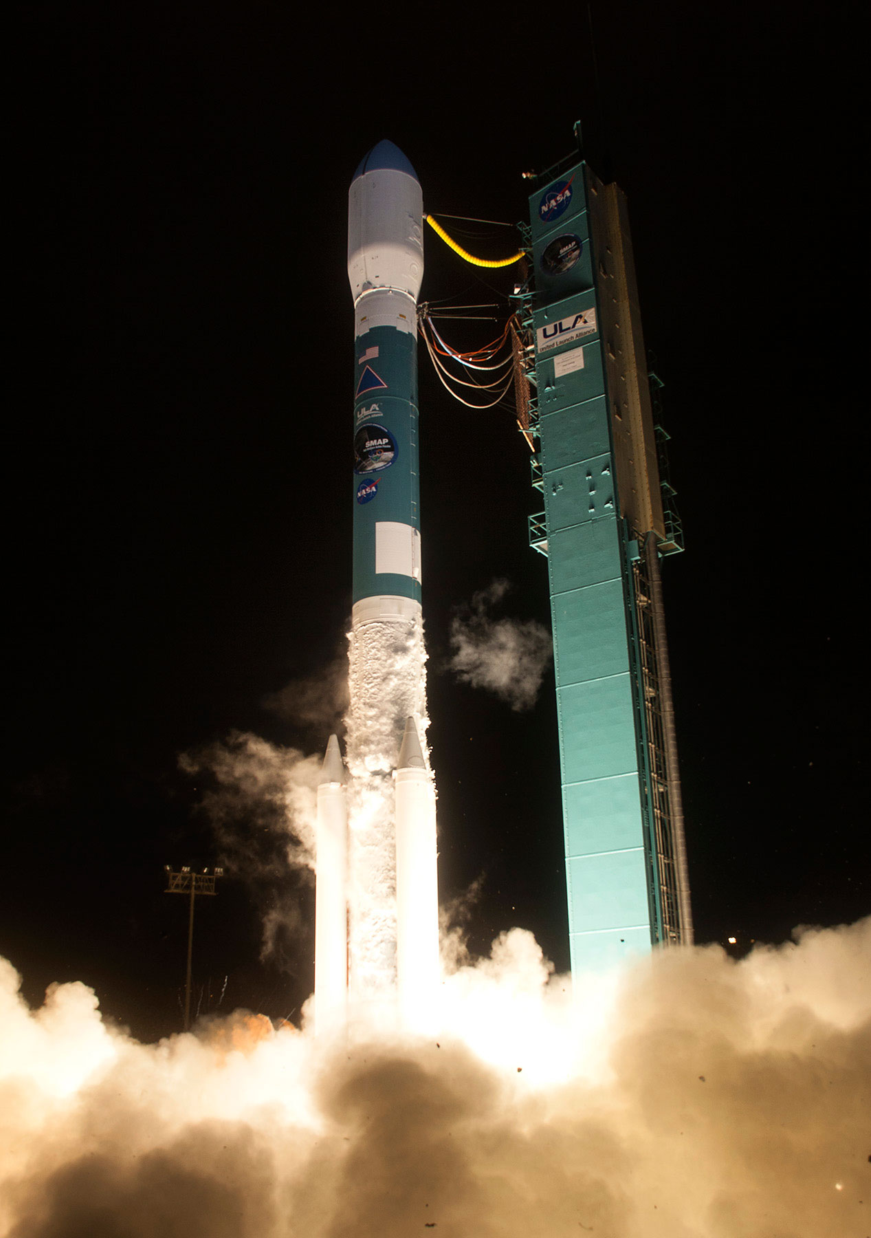
The Soil Moisture Active Passive (SMAP) observatory, a mission with broad applications for science and society, lifted off at 6:22 a.m. PST (9:22 a.m. EST) Saturday from Vandenberg Air Force Base, California, on a United Launch Alliance Delta II rocket.
About 57 minutes after liftoff, SMAP separated from the rocket's second stage into an initial 411- by 425-mile (661- by 685-kilometer) orbit. After a series of activation procedures, the spacecraft established communications with ground controllers and deployed its solar array. Initial telemetry shows the spacecraft is in excellent health.
SMAP now begins a three-year mission that will figuratively scratch below Earth's surface to expand our understanding of a key component of the Earth system that links the water, energy and carbon cycles driving our living planet. SMAP’s combined radar and radiometer instruments will peer into the top 2 inches (5 centimeters) of soil, through clouds and moderate vegetation cover, day and night, to produce the highest-resolution, most accurate soil moisture maps ever obtained from space.
The mission will help improve climate and weather forecasts and allow scientists to monitor droughts and better predict flooding caused by severe rainfall or snowmelt -- information that can save lives and property. In addition, since plant growth depends on the amount of water in the soil, SMAP data will allow nations to better forecast crop yields and assist in global famine early-warning systems.
"The launch of SMAP completes an ambitious 11-month period for NASA that has seen the launch of five new Earth-observing space missions to help us better understand our changing planet," said NASA Administrator Charles Bolden. "Scientists and policymakers will use SMAP data to track water movement around our planet and make more informed decisions in critical areas like agriculture and water resources."
SMAP also will detect whether the ground is frozen or thawed. Detecting variations in the timing of spring thaw and changes in the length of the growing season will help scientists more accurately account for how much carbon plants are removing from Earth's atmosphere each year.
"The next few years will be especially exciting for Earth science thanks to measurements from SMAP and our other new missions," said Michael Freilich, director of the Earth Science Division of NASA’s Science Mission Directorate in Washington. "Each mission measures key variables that affect Earth’s environment. SMAP will provide new insights into the global water, energy, and carbon cycles. Combining data from all our orbiting missions will give us a much better understanding of how the Earth system works."
SMAP will orbit Earth from pole to pole every 98.5 minutes, repeating the same ground track every eight days. Its 620-mile (1,000-kilometer) measurement swath allows SMAP to cover Earth’s entire equatorial regions every three days and higher latitudes every two days. The mission will map global soil moisture with about 5.6-mile (9-kilometer) resolution.
"SMAP will improve the daily lives of people around the world,” said Simon Yueh, SMAP project scientist at NASA's Jet Propulsion Laboratory (JPL) in Pasadena, California. "Soil moisture data from SMAP has the potential to significantly improve the accuracy of short-term weather forecasts and reduce the uncertainty of long-term projections of how climate change will impact Earth's water cycle.”
The SMAP team is engaged with many organizations and individuals that see immediate uses for the satellite’s data. Through workshops and tutorials, the SMAP Applications Working Group is collaborating with 45 “early adopters” to test and integrate the mission's data products into many different applications. Early adopters include weather forecasters from several nations, as well as researchers and planners from the U.S. Department of Agriculture, U.S. Geological Survey, U.S. Centers for Disease Control and Prevention, and the United Nations World Food Programme.
During the next 90 days, SMAP and its ground system will be commissioned to ensure they are fully functional and are ready to begin routine science data collection. A key milestone will be the deployment of the spacecraft’s instrument boom and 20-foot- (6-meter)-diameter reflector antenna. The observatory will be maneuvered to its final 426-mile (685-kilometer), near-polar operational orbit, and the antenna will spin up to 14.6 revolutions per minute.
SMAP science operations will then begin, and SMAP data will be calibrated and validated. The first release of SMAP soil moisture data products is expected within nine months. Fully validated science data are expected to be released within 15 months.
Robert Pearlman Editor
Posts: 42988 From: Houston, TX Registered: Nov 1999
posted 09-02-2015 03:13 PM
NASA release
NASA Soil Moisture Radar Ends Operations, Mission Science Continues
Mission managers for NASA's Soil Moisture Active Passive (SMAP) observatory have determined that its radar, one of the satellite's two science instruments, can no longer return data. However, the mission, which was launched in January to map global soil moisture and detect whether soils are frozen or thawed, continues to produce high-quality science measurements supporting SMAP's objectives with its radiometer instrument.
The SMAP mission is designed to help scientists understand the links between Earth's water, energy and carbon cycles and enhance our ability to monitor and predict natural hazards like floods and droughts. SMAP remains an important data source to aid Earth system modeling and studies. SMAP data have additional practical applications, including improved weather forecasting and crop yield predictions.
The SMAP spacecraft continues normal operations and the first data release of soil moisture products is expected in late September.
"Although some of the planned applications of SMAP data will be impacted by the loss of the radar, the SMAP mission will continue to produce valuable science for important Earth system studies," said Dara Entekhabi, SMAP Science Team lead at the Massachusetts Institute of Technology in Cambridge.
On July 7, SMAP's radar stopped transmitting due to an anomaly involving the radar's high-power amplifier (HPA). The HPA is designed to boost the power level of the radar's pulse to more than 500 watts, ensuring the energy scattered from Earth's surface can be accurately measured.
The SMAP project at NASA's Jet Propulsion Laboratory (JPL) in Pasadena, California, formed an anomaly team to investigate the HPA issue and determine whether normal operation could be recovered. A series of diagnostic tests and procedures was performed on both the spacecraft and on the ground using flight spare parts.
Following an unsuccessful attempt on Aug. 24 to power up the radar unit, the project had exhausted all identified possible options for recovering nominal operation of the HPA and concluded the radar is likely not recoverable.
NASA has appointed a mishap investigation board to conduct a comprehensive review of the circumstances that led to the HPA anomaly in order to determine how the anomaly occurred and how such events can be prevented on future missions. JPL also will convene a separate failure review board that will work with the NASA investigation.
SMAP was launched Jan. 31 and began its science mission in April, releasing its first global maps of soil moisture on April 21. To date, the mission has collected more than four months of science data, almost three months with the radar operating. SMAP scientists plan to release beta-quality soil moisture data products at the end of September, with validated data planned for release in April 2016.
SMAP's radar allowed the mission's soil moisture and freeze-thaw measurements to be resolved to smaller regions of Earth – about 5.6 miles (9 kilometers) for soil moisture and 1.9 miles (3 kilometers) for freeze-thaw. Without the radar, the mission's resolving power will be limited to regions of almost 25 miles (40 kilometers) for soil moisture and freeze-thaw. The mission will continue to meet its requirements for soil moisture accuracy and will produce global soil moisture maps every two to three days.
SMAP's active radar and passive radiometer instruments are designed to complement each other and mitigate the limitations of each measurement alone. The radar enabled high-resolution measurements of up to 1.9 miles, but with lower accuracy for sensing surface soil moisture. In contrast, the microwave radiometer is more accurate in its measurements but has lower resolution of about 25 miles. By combining the active and passive measurements, SMAP was designed to estimate soil moisture at a resolution of 5.6 miles.
The nearly three months of coincident measurements by the two instruments are a first of their kind. The combined data set allows scientists to assess the benefit of this type of combined measurement approach for future missions. Scientists now are developing algorithms to produce a freeze-thaw data product at 25-mile resolution from the radiometer data. They also are evaluating whether the 25-mile radiometer soil moisture resolution can be improved.
Based on the available SMAP mission data, scientists have identified other useful science measurements that can be derived from the radiometer data, such as sea surface salinity and high winds over the ocean surface. Over the next several months, the SMAP project and NASA will work to determine how to implement these new measurements into the project's data products.


 posted 01-31-2015 12:05 PM