|
|

|
|
Author
|
Topic: Star charts used during Project Mercury
|
Zoo Keeper
Member Posts: 50
From: Akron, OH
Registered: Feb 2021
|
 posted 10-28-2023 07:52 AM
   
There have been several excellent topics on collectSPACE and elsewhere discussing the star charts utilized during Gemini and Apollo missions. I have been attempting to research the star charts (star navigation devices) used during Mercury missions. From the paper Star Charts for Manned Space Flight by Ted A. Guillory, Gene E. Gentry, and John W. O'Neill: Mercury and Gemini Mission star charts were used primarily for star recognition, for backup attitude reference, and as visual aids in conducting scientific experiments. Existing star charts were inadequate in both the type of projection and materials, thus requiring development of new star charts. The Mercury mission star charts were projections centered about the orbital plane. The visible star fields were depicted versus Ground Elapsed Time (GET, elapsed time since lift-off) for Blunt End Forward (BEF) and Small End Forward (SEF) orbital rate flight. Orbital rate BEF and SEF attitudes were convenient for both the crewman and the control system. The primary advantage of the Mercury star charts was that the field-of-view was shown continually for the entire mission. A major disadvantage was that several charts were required to follow the motion of the projected orbital plane through the celestial sphere as it moved with the earth's rotation during the daily launch window. Additionally, for long duration missions even more charts were necessary to account for orbital precession. From my own research: - Mercury Redstone 3 and Mercury Redstone 4
I am unaware of any star charts flown on these brief suborbital missions. Shepard did not see any stars during MR-3. Grissom located what appeared to be a star during MR-4, with subsequent analysis indicating that he saw the planet Venus. - Mercury Atlas 6
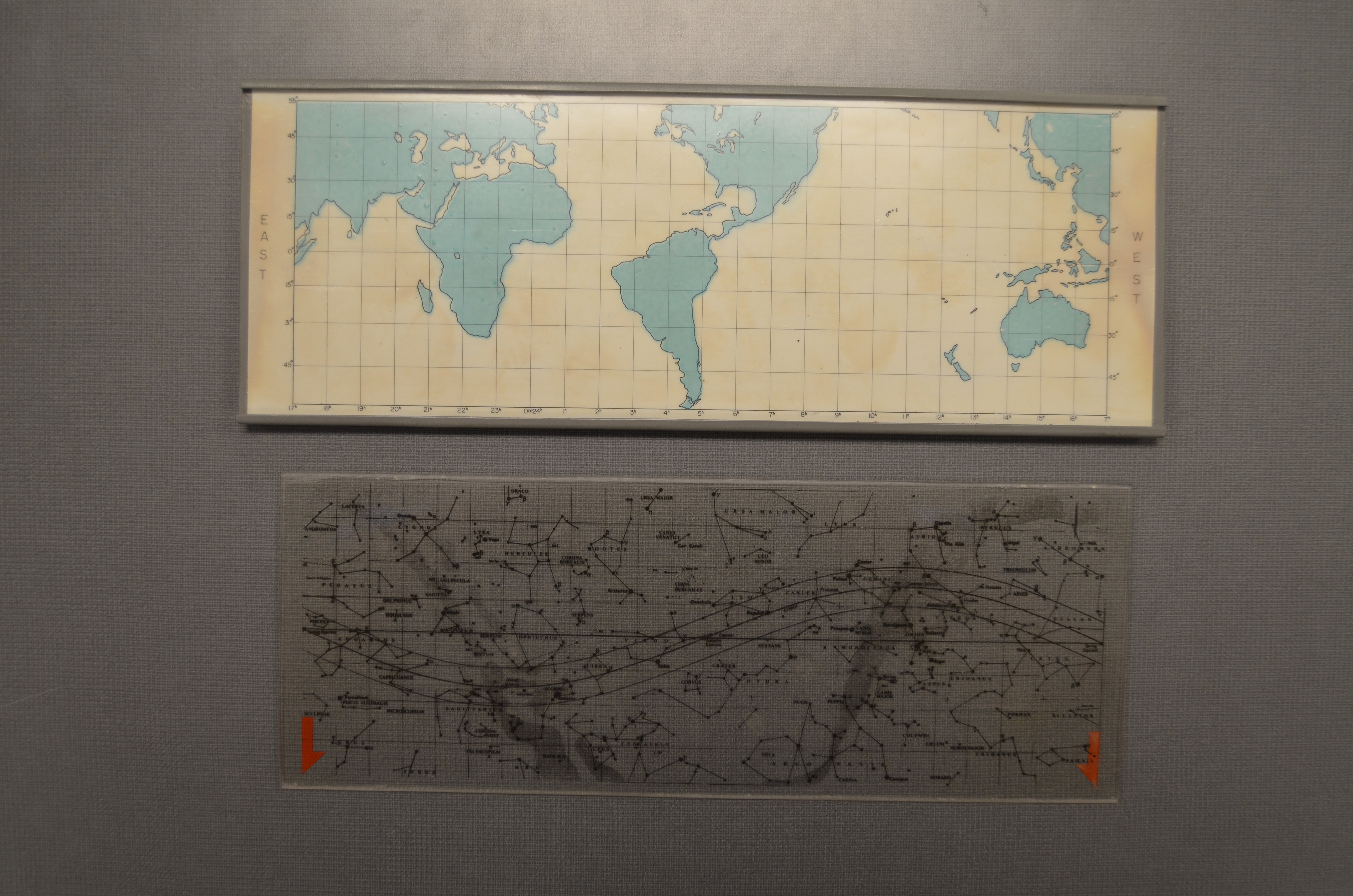
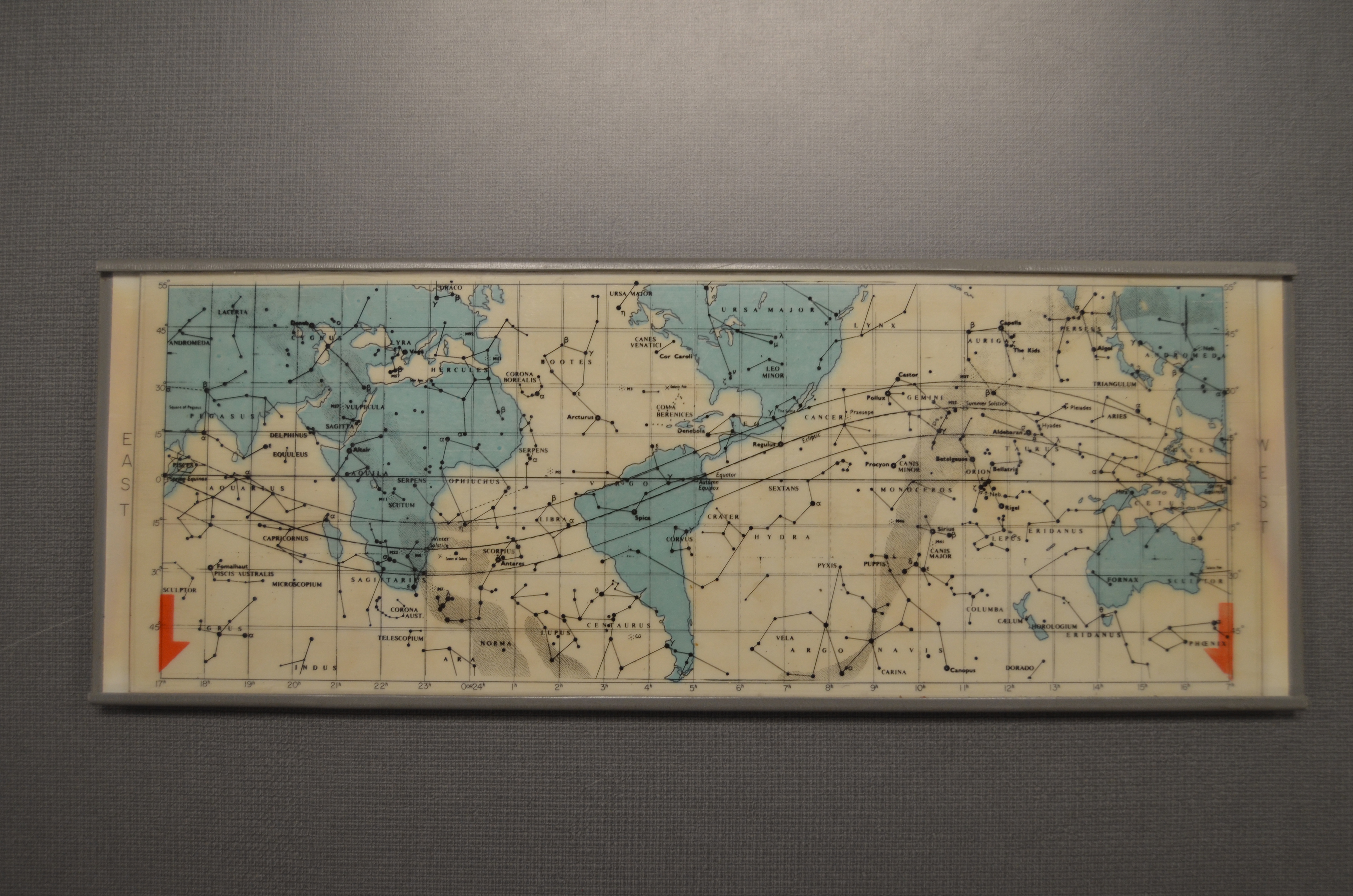
Mercury Atlas 6 carried a 10.25" x 3.75" star chart produced by Grumman as a backup navigational aid. The piece of equipment featured a mirrored map of the Earth sandwiched between a gray tray and a clear acrylic plate that displayed constellations and the mission's orbital path. A line ran lengthwise along the center of the chart to represent the orbital plane. The reverse side featured two circular maps with the Grumman logo in the center. The star chart was housed in a rectangular black pouch that utilized a button for closure. A training star chart and the flown star chart of the same design are in the John H. Glenn Archives of The Ohio State University, with the flown example on display at the NASA Glenn Visitor Center at Great Lakes Science Center. A photograph of MA-6's chart assembly can be found here. - Mercury Atlas 7
Carpenter carried a star chart on his mission stowed in a chart holder located below the capsule's periscope. I have found no photographic records of the star chart. MA-7's flight plan describes the charts as "very similar to those used in MA-6", likely indicating that few design changes occurred between the two missions. Upon retrieving the star chart inserts one hour and four minutes into the mission, Carpenter reported that the finish on the chart made it too shiny and reflective to read, requiring white lights to be turned on for its use. - Mercury Atlas 8
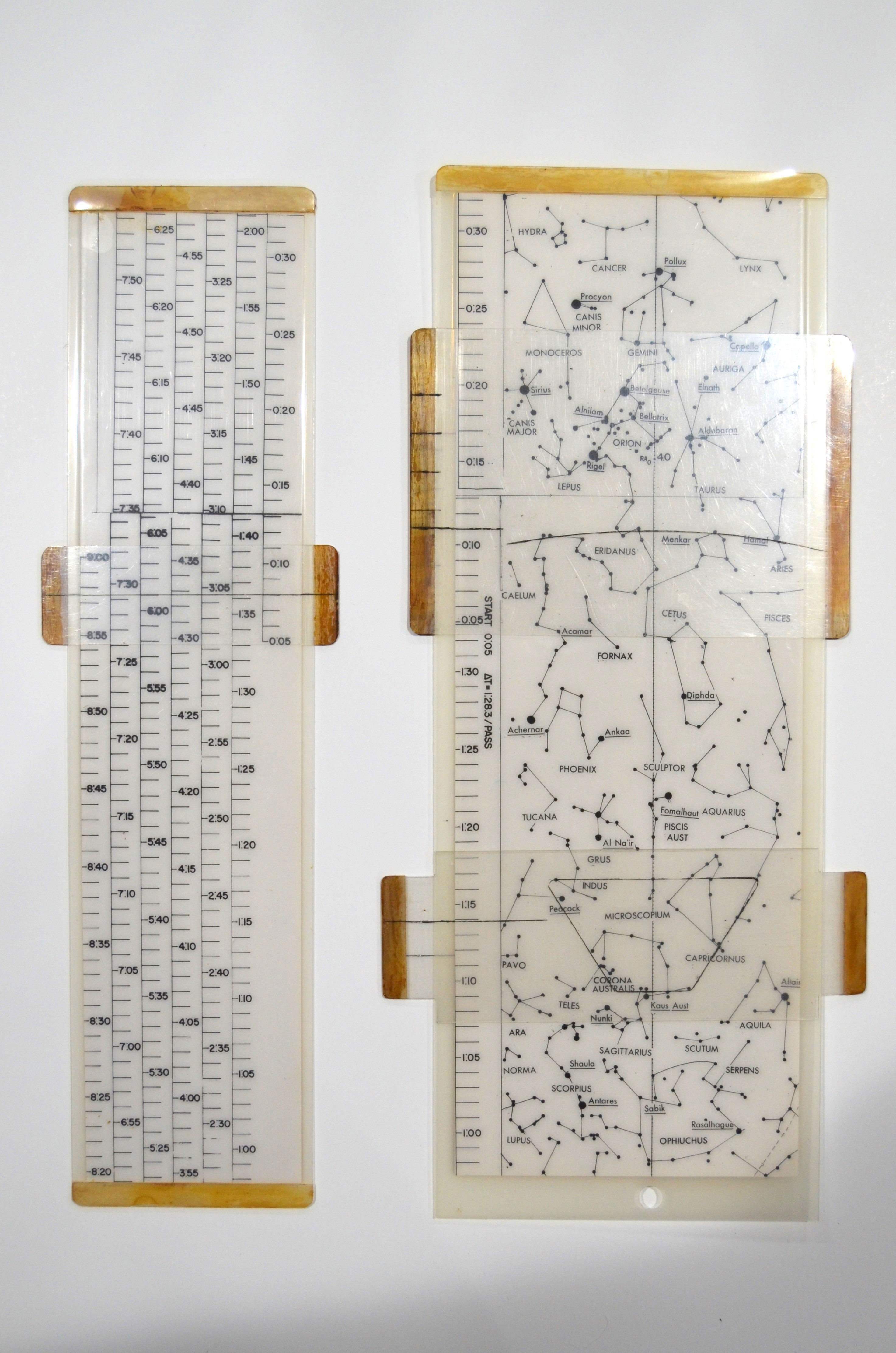
Schirra carried a new design of star chart from Glenn's mission, which was stowed in a chart case in a compartment of the spacecraft instrument panel. Photographic records in the MA-8 Description and Performance Analysis show a nearly identical star chart to those of Mercury Atlas 9 and Gene Kranz's training charts described in the sections below. The charts are laminated documents displaying only constellations and a lengthwise orbital plane line on a white background. In the photographed example, a scale for ground elapsed time is located along the lengthwise edge. An overlay tool in the shape of a spacecraft window is present. The MA-8 star charts gave five separate plots of star positions near the orbital plane. Each chart was valid for a launch within a 30 minute period. As a result, these charts displayed star locations for a lift-off between 6:46 am and 9:16 am EST. The charts no longer displayed a numeric scale of the degrees of pitch in each direction of the orbital plane, but showed constellations with 40 degrees in each direction with a field of view from the window overlay tool of 30 degrees in each direction. In addition to the star charts, Schirra carried a time conversion device to reference elapsed times in the first orbit to elapsed times in the following orbits. This determined the position on the star chart which corresponded to any elapsed time.
Photographs of MA-8's star chart and conversion device can be found in Figure 39 and 40 here. - Mercury Atlas 9
Cooper carried star charts stowed in the writing desk assembly located in front of the main panel pedestal. These star charts are nearly identical to those of Mercury Atlas 8 and Gene Kranz's training charts. Photographic records in The Triumph of Astronaut L. Gordon Cooper, Jr. and the Faith 7 show features such as a Velcro strip widthwise along the edge, which are likely present in the MA-8 star charts but are difficult to identify in their low-quality photocopy. Cooper found the star charts invaluable, but noted how little of the overall star field can be seen from the spacecraft window and recommended additional training for future missions. Cooper's mission included an experimental continuous flight plan strip, which contained star chart reference times with day-night overlays similar to the function of the time conversion device on MA-8.
A photograph of MA-9's star chart can be found here. - Mercury Mission Control and Ground Tracking Stations
It appears that these charts were additionally utilized on the ground in Mercury Mission Control and tracking stations. Little documentation seems to exist on the use of the charts in these locations. If anyone has resources to contribute below, it would add valuable information. In 2006, Gene Kranz offered a set of 10.75" x 4" star charts for sale individually through Steve Hankow of Farthest Reaches. The charts are of the same design flown on the later Mercury missions, with Kranz adding that these examples were used in training. As these charts appear to be similar to MA-8 and MA-9, it can be assumed that the flown charts are also double-sided and around the same dimensions. Given the timeframe of the chart design, Kranz would have likely acquired these charts during his time as Assistant Flight Director under Chris Kraft. These are the only Mercury star charts I have seen sold to private collectors. Photographs of Kranz's star charts can be found on most of the usual auction websites.
Lingering QuestionsI would invite anyone to share information that can be added to or clarified from the above information. Who produced the flown charts? Are any of the flown charts known to exist today apart from Glenn's? Does anyone know of unflown extant examples that do not originate from Kranz? |
Philip
Member Posts: 6243
From: Brussels, Belgium
Registered: Jan 2001
|
posted 11-03-2023 03:33 AM
Interesting topic, remember the early 1960s "Eyes on the Stars" program, during which the Mercury, Gemini and Apollo astronauts were trained in celestial navigation at the Morehead planetarium in North Carolina.For Apollo, training took place at MIT. |
Lou Chinal
Member Posts: 1389
From: Staten Island, NY
Registered: Jun 2007
|
posted 11-04-2023 07:01 PM
You might want to pick up a copy of "Space Navigation Handbook." I think it came in between Mercury - Gemini. |
Zoo Keeper
Member Posts: 50
From: Akron, OH
Registered: Feb 2021
|
posted 11-22-2023 05:52 PM
A research trip to The Ohio State University's John H. Glenn Archives uncovered some great documentation. Glenn donated his archives to OSU in 1999 in conjunction with the creation of the John Glenn Institute for Public Service and Public Policy. The collection holds a staggering 2,000 cubic feet of documents and artifacts from throughout his time as an aviator, astronaut, and senator. A big thank you and credit to their staff for the opportunity. In August 1962, NASA was finishing the five-month, 24-country world tour of Friendship 7 and was deciding the disposition of some Mercury Atlas 6 hardware. On August 3, 1962, Robert Voas wrote a memo that transferred 19 itemized flown artifacts from him to Robert Gordon for subsequent transmittal to the Smithsonian. A further 15 itemized artifacts would later be transferred to the Smithsonian in a ceremony for the first anniversary of the mission. In the set of 19 artifacts was a star chart flown on the mission. The chart was black in color and housed in a plastic sleeve. The sleeve featured a window overlay tool that could be slid across the star chart. The chart appears to have shown times for all three of Glenn's orbits at the bottom edge. As MA-7's flight plan describes that mission's flown chart as "very similar to those used in MA-6", it is presumed that this example also represents the type of star chart flown on that mission. While the Smithsonian states in their online MA-6 star chart description that it was transferred with the Friendship 7 capsule in 1963, a November 1962 memo from Philip S. Hopkins and accompanying Polaroid photos show the Smithsonian was in possession of the star chart soon after its transmittal from Voas. A photo of MA-6's star chart can be found here. So what is the star chart described for MA-6 in my post above?  
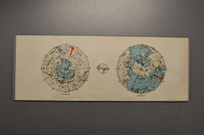
Grumman Aircraft Corporation created the "Emergency Astro-Navigation Device for Low-Orbit Manned Satellites" in 1960. In addition to the description above, recently handling the training version of the device provided some additional observations. The tray is made of a thick gray plastic with the mirrored Mercator projection glued to its surface. The plastic slide moves to either side and can be removed from the tray altogether. The reverse's two maps are 2.75" in diameter and feature spinnable plastic circles with red arrows similar to the front Mercator map. The navigation aid was a slide rule-like device primarily designed to be used in an emergency situation. If the spacecraft was placed in an unintended orbit, the astronaut can determine his position over the Earth even when the ground is obscured by clouds or darkness by utilizing the astro-navigation device in conjunction with a sideral clock using Greenwich sideral time. To use the astro-navigation device, note that the Earth's surface is divided into 24 sidereal time zones at the bottom of the device. When one of the red arrows on the left or right of the plastic slide is set to zero, we have the sky as it is projected on the Earth at zero Greenwich sidereal time. The arrow to be used is the one that allows the zenith point to remain on the map. For each hour of sidereal time that passes, the arrow must be moved to the right by one time zone to display the constellations as they are seen on the Earth. This will give the astronaut their location above the Earth regardless of if the spacecraft is on its intended orbital path. For example, an astronaut notes that his zenith coincides with the constellation Lyra by observing the visible constellations in the sky. The astronaut will use a grease pencil to mark Lyra on the plastic slide of constellations. Using the sidereal clock, the astronaut notes that he is 2.5 hours Greenwich sidereal time into the mission. The plastic slide's left arrow is placed at 0h and is moved 2.5h to the right. The zenith point then appears on the map over California, which gives him the previously unknown location of the spacecraft. A letter from Grumman's Henry C. Courten was written to Astronaut Scott Carpenter dated September 20, 1960. The letter describes a "first-class blunder" where Grumman accidentally mirrored the sidereal time zone text along with the Mercator projection on the prototype model. Corrected models were to be brought with on their next meeting, and Courten looked forward to hearing the results of Carpenter's evaluation. As Carpenter's assigned specialty area during Mercury was navigation and navigational aids, it appears that he served as Grumman's point of contact for the astro-navigation device. Glenn's Mercury Atlas 6 flight therefore carried two differing star charts for moderately different purposes, although Grumman did not use the term to describe their device. It is unclear if this type of device was flown on later missions. |
Zoo Keeper
Member Posts: 50
From: Akron, OH
Registered: Feb 2021
|
posted 01-04-2024 10:16 PM
Seventeen (17) years after Gene Kranz's Mercury star charts were made available to the public, the three star chart accessory tools that accompanied the set were offered for sale in December 2023. Photos of the artifacts are provided here for posterity.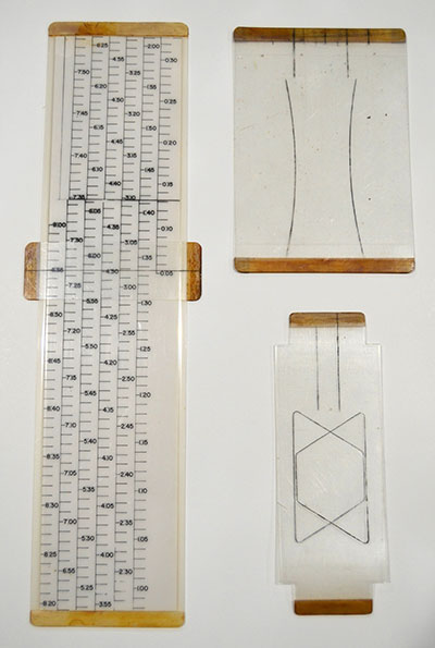 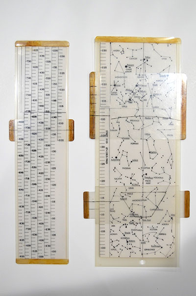
The time conversion device is very similar to the one used by Schirra on MA-8 seen in the first post's linked photo. The 10.5"x2.5" device has a sliding attachment with an indicator line used to refer elapsed times of the first orbit to elapsed times of subsequent orbits. MA-8's device shows the same type of slide but was not readily apparent from the low-resolution photocopied document. Despite his star charts appearing very similar to the examples on MA-8 and MA-9, Gene Kranz's window overlay tool is notably simplified compared to the examples used by Schirra and Cooper. Two sheets of 5"x1.75" clear plastic each feature an indicator line and the shape of a capsule window, facing opposing directions. The plastic is attached on two edges to allow a star chart to be slid in-between. The third tool is similarly designed to the window overlay tool, two 4.5"x3.125" attached plastic sheets featuring an indicator line and one curved line on each sheet. This is the first example I have seen. Does anyone recognize this tool and know what its use was on the star chart? |
Zoo Keeper
Member Posts: 50
From: Akron, OH
Registered: Feb 2021
|
posted 01-05-2024 07:10 AM
The following are the surviving Mercury star charts I have been able to locate: - John Glenn's astro-navigation device (flown on MA-6): Great Lakes Science Center, on loan from The Ohio State University's John H. Glenn Archives
- John Glenn's astro-navigation device (training): The Ohio State University's John H. Glenn Archives
- Scott Carpenter's astro-navigation device: University of Colorado Boulder's M. Scott Carpenter Papers
- Deke Slayton's astro-navigation device: Offered for auction through Aurora Galleries in November 2003, lot unsold
- Walt Cunningham's astro-navigation device: Sold through Lunar Legacies auction in November 2016
- John Glenn's star chart (flown on MA-6): Smithsonian National Air and Space Museum
- Gene Kranz's star charts: Set of charts divided across private collections. Window overlay tool, time conversion device, and unidentified accessory tool in my possession
In 1961, Grumman additionally produced a kid-friendly version of the astro-navigation device for the public titled "FOR EARTH ORBITERS…YOUR ASTROGUIDE NAVIGATOR". This paper version included information and instructions on how to use the device and compute sidereal time. The instructions are a revised version of the document "Emergency Astro-Navigation Device for Low-Orbit Manned Earth Satellites", originally prepared by Grumman's Earth Tracking Project Flight Test Department in July 1960. A fair number of these commercial astroguide navigators remain in existence today. |
kyra
Member Posts: 603
From: Louisville CO US
Registered: Aug 2003
|
posted 01-06-2024 11:53 AM
Matthew, you really have done a stellar job, pun intended for tracking everything star related for Mercury.There is a larger story waiting to be told about the astronaut trainings at Morehead Planetarium in Chapel Hill, North Carolina. I have tracked various aspects of the space programs of the world in with regard to their relationship to the stars and astronomy. Early on most sightings were related to what sightings might be practical or usefull to orientation and the larger questions of orbit navigation. Later, this became linked to experiments in limited UV photography and navigation experiments in Gemini. During the Apollo and beyond, the sightings were directly tied to mission navigation necessities and the star catalog was hard-wired or a permanent presence in the software. While 37 stars were in the Apollo Guidance Computer, nearly 200 were tracked for awareness and documentation of the star-field by ground computers. In addition, they could be used to navigate in specific emergencies. Whether or not this was practiced for Mercury and Gemini, I have not found any specific data. | |
Contact Us | The Source for Space History & Artifacts
Copyright 1999-2024 collectSPACE. All rights reserved.

Ultimate Bulletin Board 5.47a
|
|
|
 advertisement advertisement
|